- About project
- Collections
- Indexes
- Recently viewed
-
RCIN Repositories
-
 INSTYTUT ARCHEOLOGII I ETNOLOGII POLSKIEJ AKADEMII NAUK
-
 INSTYTUT BADAŃ LITERACKICH POLSKIEJ AKADEMII NAUK
-
 INSTYTUT BADAWCZY LEŚNICTWA
-
 INSTYTUT BIOLOGII DOŚWIADCZALNEJ IM. MARCELEGO NENCKIEGO POLSKIEJ AKADEMII NAUK
-
 INSTYTUT BIOLOGII SSAKÓW POLSKIEJ AKADEMII NAUK
-
 INSTYTUT CHEMII FIZYCZNEJ PAN
-
 INSTYTUT CHEMII ORGANICZNEJ PAN
-
 INSTYTUT FILOZOFII I SOCJOLOGII PAN
-
 INSTYTUT GEOGRAFII I PRZESTRZENNEGO ZAGOSPODAROWANIA PAN
-
 INSTYTUT HISTORII im. TADEUSZA MANTEUFFLA POLSKIEJ AKADEMII NAUK
-
 INSTYTUT JĘZYKA POLSKIEGO POLSKIEJ AKADEMII NAUK
-
 INSTYTUT MATEMATYCZNY PAN
-
 INSTYTUT MEDYCYNY DOŚWIADCZALNEJ I KLINICZNEJ IM.MIROSŁAWA MOSSAKOWSKIEGO POLSKIEJ AKADEMII NAUK
-
 INSTYTUT PODSTAWOWYCH PROBLEMÓW TECHNIKI PAN
-
 INSTYTUT SLAWISTYKI PAN
-
 SIEĆ BADAWCZA ŁUKASIEWICZ - INSTYTUT TECHNOLOGII MATERIAŁÓW ELEKTRONICZNYCH
-
 MUZEUM I INSTYTUT ZOOLOGII POLSKIEJ AKADEMII NAUK
-
 INSTYTUT BADAŃ SYSTEMOWYCH PAN
-
 INSTYTUT BOTANIKI IM. WŁADYSŁAWA SZAFERA POLSKIEJ AKADEMII NAUK
-
- Search in all Repository
- Literature and maps
- Archeology
- Mills database
- Natural sciences
Advanced search
Advanced search
Advanced search
Advanced search
Advanced search

Object
Available formats:
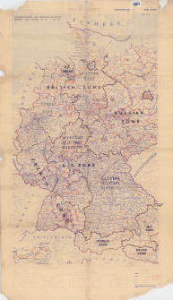
Download allTitle: Occupation zones and districts. Germany and Austria as at 1 May 46
Subtitle:
Germany and Austria as at 1 May 46
Publisher:
Place of publishing:
Description:
4th. Edition ; Scale 1:1 000 000 ; 1 map : color ; 102x60 cm, on sheet 120x69 cm ; Base map: Western Germany : administrative boundaries : scale 1:1,000,000 / photolithoģraphed by 13 M.R.S., R.E. 1944. - Third edition ; Tail margin: Autorities: Obersichtskarte 1/1,000,000 German Map 1942, G.S.G.S, 4042(A) & 4346(A). International Boundaries are as at 1937 oraz 21 A Gp No 67 Adapted from G.S.G.S MISC 149 sheet 1 and 2 ; 4500/APR/46/13 M.R.S./22/2293 ; Ancillary map: Austria : Reichgau boundaries : scale 1:4,000,000
Type of object:
Detailed Resource Type:
Format:
Resource Identifier:
Source:
CBGiOŚ. IGiPZ PAN, call no. D.11776 ; click here to follow the link
Language:
Coverage:
Rights:
Terms of use:
Digitizing institution:
Institute of Geography and Spatial Organization of the Polish Academy of Sciences
Original in:
Projects co-financed by:
Access:
Object collections:
- Digital Repository of Scientific Institutes > Partners' collections > Institute of Geography and Spatial Organization PAS (IGiPZ PAN) > Library
- Digital Repository of Scientific Institutes > Partners' collections > Institute of Geography and Spatial Organization PAS (IGiPZ PAN) > Library > Maps and atlases
- Digital Repository of Scientific Institutes > Literature > Maps/Atlases
Last modified:
Jun 2, 2021
In our library since:
Dec 30, 2019
Number of object content downloads / hits:
118
All available object's versions:
https://rcin.org.pl./publication/91054
Show description in RDF format:
Show description in RDFa format:
Show description in OAI-PMH format:
| Edition name | Date |
|---|---|
| Occupation zones and districts. Germany and Austria as at 1 May 46, 1946 | Jun 2, 2021 |
Objects Similar
Shiel, C. B. Duverg‚, P. L. Smiddy, P. Fairley, J. S.
Kayser, A. Stubbe, M.
Karski, Kamil Kobiałka, Dawid
Grundmann, Bernard Kappert, Jürgen
Menke, Tobias
Preleuthner, M. Pinsker, W.
Leligdowicz, Andrzej
Kollars, T. M., Jr.


