- O repozytorium
- Kolekcje
- Indeksy
- Historia przeglądania
-
Repozytoria RCIN
-
 INSTYTUT ARCHEOLOGII I ETNOLOGII POLSKIEJ AKADEMII NAUK
-
 INSTYTUT BADAŃ LITERACKICH POLSKIEJ AKADEMII NAUK
-
 INSTYTUT BADAWCZY LEŚNICTWA
-
 INSTYTUT BIOLOGII DOŚWIADCZALNEJ IM. MARCELEGO NENCKIEGO POLSKIEJ AKADEMII NAUK
-
 INSTYTUT BIOLOGII SSAKÓW POLSKIEJ AKADEMII NAUK
-
 INSTYTUT CHEMII FIZYCZNEJ PAN
-
 INSTYTUT CHEMII ORGANICZNEJ PAN
-
 INSTYTUT FILOZOFII I SOCJOLOGII PAN
-
 INSTYTUT GEOGRAFII I PRZESTRZENNEGO ZAGOSPODAROWANIA PAN
-
 INSTYTUT HISTORII im. TADEUSZA MANTEUFFLA POLSKIEJ AKADEMII NAUK
-
 INSTYTUT JĘZYKA POLSKIEGO POLSKIEJ AKADEMII NAUK
-
 INSTYTUT MATEMATYCZNY PAN
-
 INSTYTUT MEDYCYNY DOŚWIADCZALNEJ I KLINICZNEJ IM.MIROSŁAWA MOSSAKOWSKIEGO POLSKIEJ AKADEMII NAUK
-
 INSTYTUT PODSTAWOWYCH PROBLEMÓW TECHNIKI PAN
-
 INSTYTUT SLAWISTYKI PAN
-
 SIEĆ BADAWCZA ŁUKASIEWICZ - INSTYTUT TECHNOLOGII MATERIAŁÓW ELEKTRONICZNYCH
-
 MUZEUM I INSTYTUT ZOOLOGII POLSKIEJ AKADEMII NAUK
-
 INSTYTUT BADAŃ SYSTEMOWYCH PAN
-
 INSTYTUT BOTANIKI IM. WŁADYSŁAWA SZAFERA POLSKIEJ AKADEMII NAUK
-

Obiekt
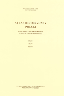
Tytuł: Województwo krakowskie w drugiej połowie XVI wieku. ; Cz. 1, Mapy, plany
Inny tytuł:
Współtwórca:
Rutkowski, Henryk, Oprac. ; Chłapowski, Krzysztof (1947– ) : Oprac. ; Institute of History of the Polish Academy of Sciences
Wydawca:
Wydawnictwo Instytutu Historii PAN ; Wydawnictwo Neriton
Miejsce wydania:
Opis:
Czasopismo/Seria/cykl:
Szczegółowy typ zasobu:
Format:
Identyfikator zasobu:
Źródło:
IH PAN, sygn. III.726/1 cz.1 Podr. ; IH PAN, sygn. III.727/1 cz.1 ; kliknij tutaj, żeby przejść
Język:
Prawa:
Zasady wykorzystania:
Copyright-protected material. May be used within the limits of statutory user freedoms
Digitalizacja:
Institute of History of the Polish Academy of Sciences
Lokalizacja oryginału:
Library of the Institute of History PAS
Dofinansowane ze środków:
Programme Innovative Economy, 2010-2014, Priority Axis 2. R&D infrastructure ; European Union. European Regional Development Fund
Dostęp:
Kolekcje, do których przypisany jest obiekt:
- Repozytorium Cyfrowe Instytutów Naukowych > Kolekcje Partnerów > Instytut Historii PAN > Atlasy historyczne
- Repozytorium Cyfrowe Instytutów Naukowych > Kolekcje Partnerów > Instytut Historii PAN > Wydawnictwa Instytutu
- Repozytorium Cyfrowe Instytutów Naukowych > Kolekcje Partnerów > Instytut Historii PAN > Wydawnictwa Instytutu > Książki
- Repozytorium Cyfrowe Instytutów Naukowych > Piśmiennictwo > Mapy/Atlasy
Data ostatniej modyfikacji:
9 gru 2021
Data dodania obiektu:
9 maj 2012
Liczba pobrań / odtworzeń:
8367
Wszystkie dostępne wersje tego obiektu:
https://rcin.org.pl./publication/6750
Wyświetl opis w formacie RDF:
Wyświetl opis w formacie RDFa:
Wyświetl opis w formacie OAI-PMH:
| Nazwa wydania | Data |
|---|---|
| Województwo krakowskie w drugiej połowie XVI wieku. Cz. 1, Mapy, plany | 9 gru 2021 |
Obiekty Podobne
Borek, Arkadiusz Orłowska, Anna Paulina (1983– ) Chłapowski, Krzysztof (1947– ) Dembiński, Paweł Gochna, Michał (1988– ) Kuc-Czerep, Marta Panecki, Tomasz Piber-Zbieranowska, Marta (1974– ) Rutkowska, Elżbieta Słomska, Katarzyna Słomski, Michał (1990– ) Sowina, Urszula (1952– ) Stępniak, Milena Suproniuk, Jarosław Szady, Bogumił (1969– ) Zbieranowski, Michał Związek, Tomasz


