- Search in all Repository
- Literature and maps
- Archeology
- Mills database
- Natural sciences
Advanced search
Advanced search
Advanced search
Advanced search
Advanced search

Object
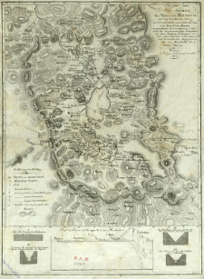
Title: Neue Charte des Thales von Mexico : und der benachbarten Gebirge
Subtitle:
Contributor:
Humboldt, Alexander von (1769–1859) : Oprac. ; Velázquez Cárdenas y Léon, Joaquín (1732–1786) : Oprac. ; Oltmanns, Jabbo (1783–1833) : Oprac. ; Martin, Louis : Rys. ; Schleuen, J. F. W. (18..-19..). Ryt. ; Geographisches Institut (Weimar)
Publisher:
im Verlage des Geograph. Institut
Place of publishing:
Description:
Skala [ca 1:500 000] ; 1 mapa : miedzior. ; 45x33 cm ; Południk zerowy Paryż ; Pod mapą profile: Profil des Canals oder Desague Real von Huehuetoca ; Die alte Bruc̈ke von Huehuetoca ; Zustand des Canals bei den bestan̈digen Abwaschungen des Regens ; Die Bos̈chung die man jetzt den Seiten des Canals zu geben sucht ; Die Ub̈erreste des alten Stollens von St. Martinez
Detailed Resource Type:
Format:
File size 8,2 MB ; application/pdf
Resource Identifier:
Source:
CBGiOŚ. IGiPZ PAN, call no. Ds.8818 ; click here to follow the link
Language:
Rights:
Terms of use:
Digitizing institution:
Institute of Geography and Spatial Organization of the Polish Academy of Sciences
Original in:
Projects co-financed by:
Programme Innovative Economy, 2010-2014, Priority Axis 2. R&D infrastructure ; European Union. European Regional Development Fund
Access:
Object collections:
- Digital Repository of Scientific Institutes > Partners' collections > Institute of Geography and Spatial Organization PAS (IGiPZ PAN) > Library
- Digital Repository of Scientific Institutes > Partners' collections > Institute of Geography and Spatial Organization PAS (IGiPZ PAN) > Library > Maps and atlases
- Digital Repository of Scientific Institutes > Literature > Maps/Atlases
Last modified:
Oct 2, 2020
In our library since:
Apr 11, 2017
Number of object content downloads / hits:
239
All available object's versions:
https://rcin.org.pl./publication/56349
Show description in RDF format:
Show description in RDFa format:
Show description in OAI-PMH format:
| Edition name | Date |
|---|---|
| Neue Charte des Thales von Mexico : und der benachbarten Gebirge, 1814 | Oct 2, 2020 |
Objects Similar
Woźny, Marzena
Cervantes, F. A. Martinez, J. Gonzalez, R. M.
Skimborowicz, Hipolit Red. Zakrzewski, Walenty Red. Jenike, Ludwik Red.
Skimborowicz, Hipolit Red. Zakrzewski, Walenty Red. Jenike, Ludwik Red.
Skimborowicz, Hipolit Red. Zakrzewski, Walenty Red. Jenike, Ludwik Red.
Skimborowicz, Hipolit Red. Zakrzewski, Walenty Red. Jenike, Ludwik Red.
Skimborowicz, Hipolit Red. Zakrzewski, Walenty Red. Jenike, Ludwik Red.
Skimborowicz, Hipolit Red. Zakrzewski, Walenty Red. Jenike, Ludwik Red.

 INSTYTUT ARCHEOLOGII I ETNOLOGII POLSKIEJ AKADEMII NAUK
 INSTYTUT BADAŃ LITERACKICH POLSKIEJ AKADEMII NAUK
 INSTYTUT BADAWCZY LEŚNICTWA
 INSTYTUT BIOLOGII DOŚWIADCZALNEJ IM. MARCELEGO NENCKIEGO POLSKIEJ AKADEMII NAUK
 INSTYTUT BIOLOGII SSAKÓW POLSKIEJ AKADEMII NAUK
 INSTYTUT CHEMII FIZYCZNEJ PAN
 INSTYTUT CHEMII ORGANICZNEJ PAN
 INSTYTUT FILOZOFII I SOCJOLOGII PAN
 INSTYTUT GEOGRAFII I PRZESTRZENNEGO ZAGOSPODAROWANIA PAN
 INSTYTUT HISTORII im. TADEUSZA MANTEUFFLA POLSKIEJ AKADEMII NAUK
 INSTYTUT JĘZYKA POLSKIEGO POLSKIEJ AKADEMII NAUK
 INSTYTUT MATEMATYCZNY PAN
 INSTYTUT MEDYCYNY DOŚWIADCZALNEJ I KLINICZNEJ IM.MIROSŁAWA MOSSAKOWSKIEGO POLSKIEJ AKADEMII NAUK
 INSTYTUT PODSTAWOWYCH PROBLEMÓW TECHNIKI PAN
 INSTYTUT SLAWISTYKI PAN
 SIEĆ BADAWCZA ŁUKASIEWICZ - INSTYTUT TECHNOLOGII MATERIAŁÓW ELEKTRONICZNYCH
 MUZEUM I INSTYTUT ZOOLOGII POLSKIEJ AKADEMII NAUK
 INSTYTUT BADAŃ SYSTEMOWYCH PAN
 INSTYTUT BOTANIKI IM. WŁADYSŁAWA SZAFERA POLSKIEJ AKADEMII NAUK


