- Wyszukaj w całym Repozytorium
- Piśmiennictwo i mapy
- Archeologia
- Baza Młynów
- Nauki przyrodnicze
Wyszukiwanie zaawansowane
Wyszukiwanie zaawansowane
Wyszukiwanie zaawansowane
Wyszukiwanie zaawansowane
Wyszukiwanie zaawansowane

Obiekt
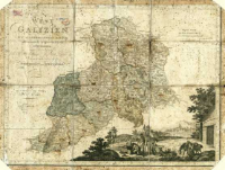
Tytuł: West-Galizien
Współtwórca:
Metzburg, Georg Ignaz von (1735–1798) : Kart. ; Liechtenstern, Johann : Rys. ; Junker, Keresztély (1757–1841) : Ryt. ; T. Mollo et Compagnie
Wydawca:
Miejsce wydania:
Opis:
Skala [ca 1:870 000] ; 1 mapa : miedzior., kolor. ręcznie ; 42x56 cm ; Auf allerhoechsten Befehl astronomisch-trigonometrisch aufgenommen unter der Leitung des K. K. Raths und öffentlichen Lehrers der Mathematik Freyherrn von Metzburg ; Gezeichnet durch Joh. v. Lichtenstern, Ing. ; Gestochen zu Wien von Ch. Junker. ; Tyt. w lewej górnej części ark., nad dolną ramką mapy scena przedstawiająca pomiar terenu, w tle fragment panoramy Krakowa ; Południk zerowy Ferro ; Brak legendy do mapy. Nazwy geogr. na mapie w jęz. pol., w pisowni bez znaków diakrytycznych ; Wg cyt. źródła mapa jest redukcją 27-arkuszowej rękopiśmiennej mapy w skali 1:72 000, oprac. na podstawie zdjęcia topogr. wykonanego w latach 1796-1799 pod kier. G. I. Metzburga ; Cyt. w.: CKZKwP. - 2000, Z. 6, s. 121, poz. 134
Szczegółowy typ zasobu:
Format:
Identyfikator zasobu:
Źródło:
CBGiOŚ. IGiPZ PAN, sygn. Ds.8001 [II.4B-1] ; kliknij tutaj, żeby przejść
Język:
Prawa:
Zasady wykorzystania:
Digitalizacja:
Instytut Geografii i Przestrzennego Zagospodarowania Polskiej Akademii Nauk
Lokalizacja oryginału:
Dofinansowane ze środków:
Program Operacyjny Innowacyjna Gospodarka, lata 2010-2014, Priorytet 2. Infrastruktura strefy B + R ; Unia Europejska. Europejski Fundusz Rozwoju Regionalnego
Dostęp:
Kolekcje, do których przypisany jest obiekt:
- Repozytorium Cyfrowe Instytutów Naukowych > Kolekcje Partnerów > Instytut Geografii i Przestrzennego Zagospodarowania PAN > Biblioteka Instytutu
- Repozytorium Cyfrowe Instytutów Naukowych > Kolekcje Partnerów > Instytut Geografii i Przestrzennego Zagospodarowania PAN > Biblioteka Instytutu > Mapy i atlasy
- Repozytorium Cyfrowe Instytutów Naukowych > Piśmiennictwo > Mapy/Atlasy
Data ostatniej modyfikacji:
2 paź 2020
Data dodania obiektu:
11 lip 2014
Liczba pobrań / odtworzeń:
700
Wszystkie dostępne wersje tego obiektu:
https://rcin.org.pl./publication/52549
Wyświetl opis w formacie RDF:
Wyświetl opis w formacie RDFa:
Wyświetl opis w formacie OAI-PMH:
| Nazwa wydania | Data |
|---|---|
| Metzburg, Georg Ignaz von (1735-1798). Kart., 1799, West-Galizien | 2 paź 2020 |
Obiekty Podobne
Güssefeld, Franz Ludwig (1744–1808)
Lotter, Tobias Conrad (1717–1777)
Vil'breht, Aleksandr Mihajlovič (1756–1823) Ušakov, K. Rys.

 INSTYTUT ARCHEOLOGII I ETNOLOGII POLSKIEJ AKADEMII NAUK
 INSTYTUT BADAŃ LITERACKICH POLSKIEJ AKADEMII NAUK
 INSTYTUT BADAWCZY LEŚNICTWA
 INSTYTUT BIOLOGII DOŚWIADCZALNEJ IM. MARCELEGO NENCKIEGO POLSKIEJ AKADEMII NAUK
 INSTYTUT BIOLOGII SSAKÓW POLSKIEJ AKADEMII NAUK
 INSTYTUT CHEMII FIZYCZNEJ PAN
 INSTYTUT CHEMII ORGANICZNEJ PAN
 INSTYTUT FILOZOFII I SOCJOLOGII PAN
 INSTYTUT GEOGRAFII I PRZESTRZENNEGO ZAGOSPODAROWANIA PAN
 INSTYTUT HISTORII im. TADEUSZA MANTEUFFLA POLSKIEJ AKADEMII NAUK
 INSTYTUT JĘZYKA POLSKIEGO POLSKIEJ AKADEMII NAUK
 INSTYTUT MATEMATYCZNY PAN
 INSTYTUT MEDYCYNY DOŚWIADCZALNEJ I KLINICZNEJ IM.MIROSŁAWA MOSSAKOWSKIEGO POLSKIEJ AKADEMII NAUK
 INSTYTUT PODSTAWOWYCH PROBLEMÓW TECHNIKI PAN
 INSTYTUT SLAWISTYKI PAN
 SIEĆ BADAWCZA ŁUKASIEWICZ - INSTYTUT TECHNOLOGII MATERIAŁÓW ELEKTRONICZNYCH
 MUZEUM I INSTYTUT ZOOLOGII POLSKIEJ AKADEMII NAUK
 INSTYTUT BADAŃ SYSTEMOWYCH PAN
 INSTYTUT BOTANIKI IM. WŁADYSŁAWA SZAFERA POLSKIEJ AKADEMII NAUK


