- About project
- Collections
- Indexes
- Recently viewed
-
RCIN Repositories
-
 INSTYTUT ARCHEOLOGII I ETNOLOGII POLSKIEJ AKADEMII NAUK
-
 INSTYTUT BADAŃ LITERACKICH POLSKIEJ AKADEMII NAUK
-
 INSTYTUT BADAWCZY LEŚNICTWA
-
 INSTYTUT BIOLOGII DOŚWIADCZALNEJ IM. MARCELEGO NENCKIEGO POLSKIEJ AKADEMII NAUK
-
 INSTYTUT BIOLOGII SSAKÓW POLSKIEJ AKADEMII NAUK
-
 INSTYTUT CHEMII FIZYCZNEJ PAN
-
 INSTYTUT CHEMII ORGANICZNEJ PAN
-
 INSTYTUT FILOZOFII I SOCJOLOGII PAN
-
 INSTYTUT GEOGRAFII I PRZESTRZENNEGO ZAGOSPODAROWANIA PAN
-
 INSTYTUT HISTORII im. TADEUSZA MANTEUFFLA POLSKIEJ AKADEMII NAUK
-
 INSTYTUT JĘZYKA POLSKIEGO POLSKIEJ AKADEMII NAUK
-
 INSTYTUT MATEMATYCZNY PAN
-
 INSTYTUT MEDYCYNY DOŚWIADCZALNEJ I KLINICZNEJ IM.MIROSŁAWA MOSSAKOWSKIEGO POLSKIEJ AKADEMII NAUK
-
 INSTYTUT PODSTAWOWYCH PROBLEMÓW TECHNIKI PAN
-
 INSTYTUT SLAWISTYKI PAN
-
 SIEĆ BADAWCZA ŁUKASIEWICZ - INSTYTUT TECHNOLOGII MATERIAŁÓW ELEKTRONICZNYCH
-
 MUZEUM I INSTYTUT ZOOLOGII POLSKIEJ AKADEMII NAUK
-
 INSTYTUT BADAŃ SYSTEMOWYCH PAN
-
 INSTYTUT BOTANIKI IM. WŁADYSŁAWA SZAFERA POLSKIEJ AKADEMII NAUK
-
- Search in all Repository
- Literature and maps
- Archeology
- Mills database
- Natural sciences
Advanced search
Advanced search
Advanced search
Advanced search
Advanced search

Object
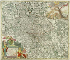
Title: Silesiæ Ducatus tam Superior quam inferior : juxta suos XVII Minores Principatus et VI Libera Dominia disterminat. Nova mappa geographica ob oculos positus
Subtitle:
Publisher:
cura et sumtibus [!] Matth. Seutteri
Place of publishing:
Description:
Skala [ca 1:730 000], podziałka liniowa Milliaria Germanica Communia 8 = [7,7 cm] ; 1 mapa : miedzior., kolor. ręcznie ; 50x57 cm ; Tyt. w prawym górnym rogu mapy, umieszczony na draperii, trzymanej przez dwa putta ; Opisane strony świata: Septentrio, Oriens, Meridies, Occidens ; W lewym dolnym rogu na cokole zwieńczonym herbem Śląska, mapa poboczna: Breslaw, [ca 1:24 000], pod nim podziałka liniowa: Milliaria Germanica communia ; Przy nazwisku M. Seuttera tytuł geografa cesarskiego: S. C. M. G. August ; Mapa wydana po 1733 r. po otrzymaniu tytułu geografa cesarskiego przez M. Seuttera ; Mapa luźna, następnie zamieszczana w atlasach M. Seuttera m. in. w Atlas novus ; BNPol online ; Imago Silesiae poz. 94., s. 72
Detailed Resource Type:
Format:
Resource Identifier:
Source:
CBGiOŚ. IGiPZ PAN, call no. Ds.8739 [II.7B-8] ; click here to follow the link
Language:
Rights:
Terms of use:
Digitizing institution:
Institute of Geography and Spatial Organization of the Polish Academy of Sciences
Original in:
Projects co-financed by:
Programme Innovative Economy, 2010-2014, Priority Axis 2. R&D infrastructure ; European Union. European Regional Development Fund
Access:
Object collections:
- Digital Repository of Scientific Institutes > Partners' collections > Institute of Geography and Spatial Organization PAS (IGiPZ PAN) > Library
- Digital Repository of Scientific Institutes > Partners' collections > Institute of Geography and Spatial Organization PAS (IGiPZ PAN) > Library > Maps and atlases
- Digital Repository of Scientific Institutes > Literature > Maps/Atlases
Last modified:
Oct 2, 2020
In our library since:
Jul 11, 2014
Number of object content downloads / hits:
232
All available object's versions:
https://rcin.org.pl./publication/52480
Show description in RDF format:
Show description in RDFa format:
Show description in OAI-PMH format:
Objects Similar
Pankiewicz, Aleksandra Rodak, Sylwia
Nowakowski, Dominik
Seutter, Matthäus (1678 – c. 1757) Lotter, Tobias Conrad (1717–1777)
Seutter, Matthäus (1678 – c. 1757) Lotter, Tobias Conrad (1717–1777)
Seutter, Matthäus (1678 – c. 1757) Lotter, Tobias Conrad (1717–1777)
Seutter, Matthäus (1678 – c. 1757) Lotter, Tobias Conrad (1717–1777)
Seutter, Matthäus (1678 – c. 1757) Lotter, Tobias Conrad (1717–1777)
Seutter, Matthäus (1678 – c. 1757) Lotter, Tobias Conrad (1717–1777)


