- About project
- Collections
- Indexes
- Recently viewed
-
RCIN Repositories
-
 INSTYTUT ARCHEOLOGII I ETNOLOGII POLSKIEJ AKADEMII NAUK
-
 INSTYTUT BADAŃ LITERACKICH POLSKIEJ AKADEMII NAUK
-
 INSTYTUT BADAWCZY LEŚNICTWA
-
 INSTYTUT BIOLOGII DOŚWIADCZALNEJ IM. MARCELEGO NENCKIEGO POLSKIEJ AKADEMII NAUK
-
 INSTYTUT BIOLOGII SSAKÓW POLSKIEJ AKADEMII NAUK
-
 INSTYTUT CHEMII FIZYCZNEJ PAN
-
 INSTYTUT CHEMII ORGANICZNEJ PAN
-
 INSTYTUT FILOZOFII I SOCJOLOGII PAN
-
 INSTYTUT GEOGRAFII I PRZESTRZENNEGO ZAGOSPODAROWANIA PAN
-
 INSTYTUT HISTORII im. TADEUSZA MANTEUFFLA POLSKIEJ AKADEMII NAUK
-
 INSTYTUT JĘZYKA POLSKIEGO POLSKIEJ AKADEMII NAUK
-
 INSTYTUT MATEMATYCZNY PAN
-
 INSTYTUT MEDYCYNY DOŚWIADCZALNEJ I KLINICZNEJ IM.MIROSŁAWA MOSSAKOWSKIEGO POLSKIEJ AKADEMII NAUK
-
 INSTYTUT PODSTAWOWYCH PROBLEMÓW TECHNIKI PAN
-
 INSTYTUT SLAWISTYKI PAN
-
 SIEĆ BADAWCZA ŁUKASIEWICZ - INSTYTUT TECHNOLOGII MATERIAŁÓW ELEKTRONICZNYCH
-
 MUZEUM I INSTYTUT ZOOLOGII POLSKIEJ AKADEMII NAUK
-
 INSTYTUT BADAŃ SYSTEMOWYCH PAN
-
 INSTYTUT BOTANIKI IM. WŁADYSŁAWA SZAFERA POLSKIEJ AKADEMII NAUK
-
- Search in all Repository
- Literature and maps
- Archeology
- Mills database
- Natural sciences
Advanced search
Advanced search
Advanced search
Advanced search
Advanced search

Object
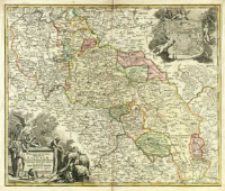
Title: Superioris et Inferioris Ducatus Silesiæ In Suos XVII Minores Principatus Et Dominia Divisi Nova Tabula
Subtitle:
Contributor:
Publisher:
Place of publishing:
Description:
Skala [ca 1:750 000], podziałka liniowa: Scala Millitaria communia Germanica ; 1 mapa : miedzior. kolor. ręcznie ; 49x58 cm, na ark. 55x64 cm ; W górnym prawym rogu mapy na zwoju umieszczony plan Wrocławia z napisem Breslau ; Opisano strony świata: Septentrio, Oriens, Meridies, Occidens ; Tyt. w kartuszu w dolnym lewym rogu mapy, umieszczony na cokole otoczonym przez postacie i atrybuty symboliczne ; Mapa po raz pierwszy opublikowana w 1712 r., początkowo ukazała się jako mapa luźna, następnie zamieszczana była w atlasach Homanna ; Południk zerowy Ferro ; BNPol online ; Cyt. w: Dzikowski. - 1939 poz. 168 (40), s. 227
Detailed Resource Type:
Format:
Resource Identifier:
Source:
CBGiOŚ. IGiPZ PAN, call no. Ds.8014[II.7B-6] ; click here to follow the link
Language:
Rights:
Terms of use:
Digitizing institution:
Institute of Geography and Spatial Organization of the Polish Academy of Sciences
Original in:
Projects co-financed by:
Programme Innovative Economy, 2010-2014, Priority Axis 2. R&D infrastructure ; European Union. European Regional Development Fund
Access:
Object collections:
- Digital Repository of Scientific Institutes > Partners' collections > Institute of Geography and Spatial Organization PAS (IGiPZ PAN) > Library
- Digital Repository of Scientific Institutes > Partners' collections > Institute of Geography and Spatial Organization PAS (IGiPZ PAN) > Library > Maps and atlases
- Digital Repository of Scientific Institutes > Literature > Maps/Atlases
Last modified:
Oct 2, 2020
In our library since:
Jul 11, 2014
Number of object content downloads / hits:
170
All available object's versions:
https://rcin.org.pl./publication/52442
Show description in RDF format:
Show description in RDFa format:
Show description in OAI-PMH format:
Objects Similar
Homann, Johann Baptist (1664–1724)
Homann, Johann Baptist (1664–1724)
Homann, Johann Baptist (1664–1724)
Homann, Johann Baptist (1664–1724)
Homann, Johann Baptist (1664–1724)
Homann, Johann Baptist (1664–1724)
Homann, Johann Baptist (1664–1724)
Homann, Johann Baptist (1664–1724)


