- About project
- Collections
- Indexes
- Recently viewed
-
RCIN Repositories
-
 INSTYTUT ARCHEOLOGII I ETNOLOGII POLSKIEJ AKADEMII NAUK
-
 INSTYTUT BADAŃ LITERACKICH POLSKIEJ AKADEMII NAUK
-
 INSTYTUT BADAWCZY LEŚNICTWA
-
 INSTYTUT BIOLOGII DOŚWIADCZALNEJ IM. MARCELEGO NENCKIEGO POLSKIEJ AKADEMII NAUK
-
 INSTYTUT BIOLOGII SSAKÓW POLSKIEJ AKADEMII NAUK
-
 INSTYTUT CHEMII FIZYCZNEJ PAN
-
 INSTYTUT CHEMII ORGANICZNEJ PAN
-
 INSTYTUT FILOZOFII I SOCJOLOGII PAN
-
 INSTYTUT GEOGRAFII I PRZESTRZENNEGO ZAGOSPODAROWANIA PAN
-
 INSTYTUT HISTORII im. TADEUSZA MANTEUFFLA POLSKIEJ AKADEMII NAUK
-
 INSTYTUT JĘZYKA POLSKIEGO POLSKIEJ AKADEMII NAUK
-
 INSTYTUT MATEMATYCZNY PAN
-
 INSTYTUT MEDYCYNY DOŚWIADCZALNEJ I KLINICZNEJ IM.MIROSŁAWA MOSSAKOWSKIEGO POLSKIEJ AKADEMII NAUK
-
 INSTYTUT PODSTAWOWYCH PROBLEMÓW TECHNIKI PAN
-
 INSTYTUT SLAWISTYKI PAN
-
 SIEĆ BADAWCZA ŁUKASIEWICZ - INSTYTUT TECHNOLOGII MATERIAŁÓW ELEKTRONICZNYCH
-
 MUZEUM I INSTYTUT ZOOLOGII POLSKIEJ AKADEMII NAUK
-
 INSTYTUT BADAŃ SYSTEMOWYCH PAN
-
 INSTYTUT BOTANIKI IM. WŁADYSŁAWA SZAFERA POLSKIEJ AKADEMII NAUK
-

Object
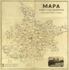
Title: Mapa powiatu ciechanowskiego
Contributor:
Publisher:
Nakł. Komitetu Wystawy Powiatowej
Place of publishing:
Description:
Skala [ca 1:90 000] ; 1 mapa ; 60x59 cm, na ark. 73x63 cm ; Tyt. z mapy ; Brak prezentacji rzeźby terenu ; Pod mapą dwie podziałki transwersalne w wiorstach i w km. oraz czarno-biała fot. ruin zamku w Ciechanowie
Detailed Resource Type:
Format:
Resource Identifier:
Source:
CBGiOŚ. IGiPZ PAN, call no. Ds.7125 [m.polit-adm.cz. Polski.2] ; click here to follow the link
Language:
Rights:
Rights Reserved - Restricted Access
Terms of use:
Digitizing institution:
Institute of Geography and Spatial Organization of the Polish Academy of Sciences
Original in:
Projects co-financed by:
Programme Innovative Economy, 2010-2014, Priority Axis 2. R&D infrastructure ; European Union. European Regional Development Fund
Access:
Object collections:
- Digital Repository of Scientific Institutes > Partners' collections > Institute of Geography and Spatial Organization PAS (IGiPZ PAN) > Library
- Digital Repository of Scientific Institutes > Partners' collections > Institute of Geography and Spatial Organization PAS (IGiPZ PAN) > Library > Maps and atlases
- Digital Repository of Scientific Institutes > Literature > Maps/Atlases
Last modified:
Oct 2, 2020
In our library since:
Jan 31, 2014
Number of object content downloads / hits:
64
All available object's versions:
https://rcin.org.pl./publication/51430
Show description in RDF format:
Show description in RDFa format:
Show description in OAI-PMH format:
| Edition name | Date |
|---|---|
| Mapa powiatu ciechanowskiego, [ante 1939] | Oct 2, 2020 |
Objects Similar
Polska. Główny Urząd Pomiarów Kraju. Wydawca Województwo Warszawskie (Polska). Urząd Wojewódzki. Wydział Pomiarów. Wydawca
Francja. Service Géographique des forces françaises libres au Levant. Wydawca
Ravenstein Geographische Verlagsanstalt und Druckerei. Wydawca
Ravenstein Geographische Verlagsanstalt und Druckerei. Wydawca
Polska. Główny Urząd Statystyczny. Biuro kartograficzne. Redaktor


