- Search in all Repository
- Literature and maps
- Archeology
- Mills database
- Natural sciences
Advanced search
Advanced search
Advanced search
Advanced search
Advanced search

Object
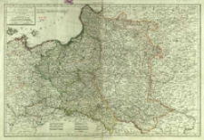
Title: Carte de l'ancien Royaume de Pologne : partagé entre La Russie, La Prusse et L-Autriche par les Traités successifs de 1772. 1793 et 1795 contenant aussi Le Royaume de Prusse
Contributor:
Chanlaire, Pierre Grégoire (1758–1817)
Publisher:
Chez le autteurs P. G. Chanlaire, Rue Geoffroy N 7, E. Mantelle, Rue du Doyenné N 2
Place of publishing:
Description:
Skala [ca 1:2.700.000], podziałka liniowa: Lieues Communes de France de 25 au Deg ; 1 mapa na 2 ark. : miedzior. kolor. ręcznie ; całość 44x63 cm ; Południk Ferro i południk paryski ; Podziałki liniowe podano również w: milach geograficznych, polskich, niemieckich, wegierskich oraz wiorstach rosyjskich ; Mapa zawiera legendę kolorów ; Granice ziem polskich po poszczególnych rozbiorach naniesione ręcznie kolorami ; Mapa pochodzi z : "Atlas Universel de géographie physique at politique", N 103 ; Rok wyd. wg.: Imago Poloniae : dawna Rzeczpospolita na mapach, dokumentach i starodrukach w zbiorach Tomasza Niewodniczańskiego. - Warszawa 2002, Poz. K56/6
Detailed Resource Type:
Format:
Resource Identifier:
Source:
CBGiOŚ. IGiPZ PAN, call no. D.14721 [I.1-C/20] ; CBGiOŚ. IGiPZ PAN, call no. Ds.8083 [I.1-C-18] ; click here to follow the link
Language:
Rights:
Terms of use:
Digitizing institution:
Institute of Geography and Spatial Organization of the Polish Academy of Sciences
Original in:
Projects co-financed by:
Programme Innovative Economy, 2010-2014, Priority Axis 2. R&D infrastructure ; European Union. European Regional Development Fund
Access:
Object collections:
- Repozytorium Cyfrowe Instytutów Naukowych > Kolekcje Partnerów > Instytut Geografii i Przestrzennego Zagospodarowania PAN > Biblioteka Instytutu
- Repozytorium Cyfrowe Instytutów Naukowych > Kolekcje Partnerów > Instytut Geografii i Przestrzennego Zagospodarowania PAN > Biblioteka Instytutu > Mapy i atlasy
- Repozytorium Cyfrowe Instytutów Naukowych > Piśmiennictwo > Mapy/Atlasy
Last modified:
Oct 2, 2020
In our library since:
Jan 30, 2014
Number of object content downloads / hits:
201
All available object's versions:
https://rcin.org.pl./publication/51408
Show description in RDF format:
Show description in RDFa format:
Show description in OAI-PMH format:
Objects Similar
Mentelle, Edme (1730–1815) Tardieu, Pierre François (1752–1798)
Faden, William (1749–1836)
Delisle, Guillaume (1675–1726) Buache, Philippe (1700–1773)
Sotzmann, Daniel Fridrich (1754–1840) Penningh, Harry John Glassbach, Carl Christian (1751-post 1791) Schmidt, Friedrich August Sander, Wilhelm (c. 1766 – 1836)
Müller, Franz (1755–1816) Schütz, Carl (1745–1800)
Delisle, Guillaume (1675–1726) Condet, Johannes (1711–1781)
Morden. Robert (?-1703) Browne, Christopher (fl. 1684-1712) Harris, J.
Homann, Johann Baptist (1664–1724)

 INSTYTUT ARCHEOLOGII I ETNOLOGII POLSKIEJ AKADEMII NAUK
 INSTYTUT BADAŃ LITERACKICH POLSKIEJ AKADEMII NAUK
 INSTYTUT BADAWCZY LEŚNICTWA
 INSTYTUT BIOLOGII DOŚWIADCZALNEJ IM. MARCELEGO NENCKIEGO POLSKIEJ AKADEMII NAUK
 INSTYTUT BIOLOGII SSAKÓW POLSKIEJ AKADEMII NAUK
 INSTYTUT CHEMII FIZYCZNEJ PAN
 INSTYTUT CHEMII ORGANICZNEJ PAN
 INSTYTUT FILOZOFII I SOCJOLOGII PAN
 INSTYTUT GEOGRAFII I PRZESTRZENNEGO ZAGOSPODAROWANIA PAN
 INSTYTUT HISTORII im. TADEUSZA MANTEUFFLA POLSKIEJ AKADEMII NAUK
 INSTYTUT JĘZYKA POLSKIEGO POLSKIEJ AKADEMII NAUK
 INSTYTUT MATEMATYCZNY PAN
 INSTYTUT MEDYCYNY DOŚWIADCZALNEJ I KLINICZNEJ IM.MIROSŁAWA MOSSAKOWSKIEGO POLSKIEJ AKADEMII NAUK
 INSTYTUT PODSTAWOWYCH PROBLEMÓW TECHNIKI PAN
 INSTYTUT SLAWISTYKI PAN
 SIEĆ BADAWCZA ŁUKASIEWICZ - INSTYTUT TECHNOLOGII MATERIAŁÓW ELEKTRONICZNYCH
 MUZEUM I INSTYTUT ZOOLOGII POLSKIEJ AKADEMII NAUK
 INSTYTUT BADAŃ SYSTEMOWYCH PAN
 INSTYTUT BOTANIKI IM. WŁADYSŁAWA SZAFERA POLSKIEJ AKADEMII NAUK


