- Search in all Repository
- Literature and maps
- Archeology
- Mills database
- Natural sciences
Advanced search
Advanced search
Advanced search
Advanced search
Advanced search

Object
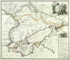
Title: Carte de la Petite Tartarie : Dressée par ordre de l'Imperatrice de toutes les Russies
Contributor:
Leth, Hendrik de (1703–1766) : Wyd. ; Schenk, Pieter (1693–1775) : Wyd.
Publisher:
chez Henry De Leth a l'enseigne du Pêcheur ; chez Pierre Schenk
Place of publishing:
Description:
Skala [ca 1:1 600 000] ; 1 mapa : miedzior., kolor. ; 41x47cm ; Południk Ferro, ustalony po obliczeniach przez katalogującego ; Brak siatki współrzędnych ; Na mapie zamieszczono pozycje wojsk rosyjskich i tureckich oraz lokalizację twierdz z objaśnieniem w parerdze ; Kartusz roccaile otoczony panopliami i postacią Tatara ; BVB online
Detailed Resource Type:
Format:
Resource Identifier:
Source:
CBGiOŚ. IGiPZ PAN, call no. Ds. 8267 [T.2/36] ; click here to follow the link
Language:
Rights:
Terms of use:
Digitizing institution:
Institute of Geography and Spatial Organization of the Polish Academy of Sciences
Original in:
Projects co-financed by:
Programme Innovative Economy, 2010-2014, Priority Axis 2. R&D infrastructure ; European Union. European Regional Development Fund
Access:
Object collections:
- Digital Repository of Scientific Institutes > Partners' collections > Institute of Geography and Spatial Organization PAS (IGiPZ PAN) > Library
- Digital Repository of Scientific Institutes > Partners' collections > Institute of Geography and Spatial Organization PAS (IGiPZ PAN) > Library > Maps and atlases
- Digital Repository of Scientific Institutes > Literature > Maps/Atlases
Last modified:
Oct 2, 2020
In our library since:
Jan 24, 2014
Number of object content downloads / hits:
59
All available object's versions:
https://rcin.org.pl./publication/51357
Show description in RDF format:
Show description in RDFa format:
Show description in OAI-PMH format:
| Edition name | Date |
|---|---|
| Carte de la Petite Tartarie : Dressée par ordre de l'Imperatrice de toutes les Russies, [post 1768] | Oct 2, 2020 |
Objects Similar
Wanner, Catherine King-Savic, Sandra Tosic, Jelena Tarkhanova, Oleksandra
Susulovsky, Andrij Winiszewska-Ślipińska, Grażyna
Butko, Matej
Trzeszczyńska, Patrycja
Ivanov, Mykyta
Polit, Beata

 INSTYTUT ARCHEOLOGII I ETNOLOGII POLSKIEJ AKADEMII NAUK
 INSTYTUT BADAŃ LITERACKICH POLSKIEJ AKADEMII NAUK
 INSTYTUT BADAWCZY LEŚNICTWA
 INSTYTUT BIOLOGII DOŚWIADCZALNEJ IM. MARCELEGO NENCKIEGO POLSKIEJ AKADEMII NAUK
 INSTYTUT BIOLOGII SSAKÓW POLSKIEJ AKADEMII NAUK
 INSTYTUT CHEMII FIZYCZNEJ PAN
 INSTYTUT CHEMII ORGANICZNEJ PAN
 INSTYTUT FILOZOFII I SOCJOLOGII PAN
 INSTYTUT GEOGRAFII I PRZESTRZENNEGO ZAGOSPODAROWANIA PAN
 INSTYTUT HISTORII im. TADEUSZA MANTEUFFLA POLSKIEJ AKADEMII NAUK
 INSTYTUT JĘZYKA POLSKIEGO POLSKIEJ AKADEMII NAUK
 INSTYTUT MATEMATYCZNY PAN
 INSTYTUT MEDYCYNY DOŚWIADCZALNEJ I KLINICZNEJ IM.MIROSŁAWA MOSSAKOWSKIEGO POLSKIEJ AKADEMII NAUK
 INSTYTUT PODSTAWOWYCH PROBLEMÓW TECHNIKI PAN
 INSTYTUT SLAWISTYKI PAN
 SIEĆ BADAWCZA ŁUKASIEWICZ - INSTYTUT TECHNOLOGII MATERIAŁÓW ELEKTRONICZNYCH
 MUZEUM I INSTYTUT ZOOLOGII POLSKIEJ AKADEMII NAUK
 INSTYTUT BADAŃ SYSTEMOWYCH PAN
 INSTYTUT BOTANIKI IM. WŁADYSŁAWA SZAFERA POLSKIEJ AKADEMII NAUK


