- About project
- Collections
- Indexes
- Recently viewed
-
RCIN Repositories
-
 INSTYTUT ARCHEOLOGII I ETNOLOGII POLSKIEJ AKADEMII NAUK
-
 INSTYTUT BADAŃ LITERACKICH POLSKIEJ AKADEMII NAUK
-
 INSTYTUT BADAWCZY LEŚNICTWA
-
 INSTYTUT BIOLOGII DOŚWIADCZALNEJ IM. MARCELEGO NENCKIEGO POLSKIEJ AKADEMII NAUK
-
 INSTYTUT BIOLOGII SSAKÓW POLSKIEJ AKADEMII NAUK
-
 INSTYTUT CHEMII FIZYCZNEJ PAN
-
 INSTYTUT CHEMII ORGANICZNEJ PAN
-
 INSTYTUT FILOZOFII I SOCJOLOGII PAN
-
 INSTYTUT GEOGRAFII I PRZESTRZENNEGO ZAGOSPODAROWANIA PAN
-
 INSTYTUT HISTORII im. TADEUSZA MANTEUFFLA POLSKIEJ AKADEMII NAUK
-
 INSTYTUT JĘZYKA POLSKIEGO POLSKIEJ AKADEMII NAUK
-
 INSTYTUT MATEMATYCZNY PAN
-
 INSTYTUT MEDYCYNY DOŚWIADCZALNEJ I KLINICZNEJ IM.MIROSŁAWA MOSSAKOWSKIEGO POLSKIEJ AKADEMII NAUK
-
 INSTYTUT PODSTAWOWYCH PROBLEMÓW TECHNIKI PAN
-
 INSTYTUT SLAWISTYKI PAN
-
 SIEĆ BADAWCZA ŁUKASIEWICZ - INSTYTUT TECHNOLOGII MATERIAŁÓW ELEKTRONICZNYCH
-
 MUZEUM I INSTYTUT ZOOLOGII POLSKIEJ AKADEMII NAUK
-
 INSTYTUT BADAŃ SYSTEMOWYCH PAN
-
 INSTYTUT BOTANIKI IM. WŁADYSŁAWA SZAFERA POLSKIEJ AKADEMII NAUK
-
- Search in all Repository
- Literature and maps
- Archeology
- Mills database
- Natural sciences
Advanced search
Advanced search
Advanced search
Advanced search
Advanced search

Object
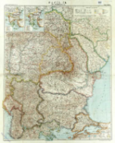
Title: Rumänien und Nachbargebieten
Subtitle:
Flemmings Kriegskarte ; Nr. 32
Contributor:
Kettler, Julius Iwan (1852–1921) : Red. ; Bludau, Alois (1861–1913) : Oprac. ; Herkt, Otto ; Carl Flemming und C. T. Wiskott Aktiengesellschaft für Verlag und Kunstdruck (Głogów)
Publisher:
Place of publishing:
Description:
Scale 1:1 500 000 ; 1 map : lithogr., col. ; 82x66 cm, sheet 88x71 cm ; Date of puiblication based on political borders: Transylvania in borders of Austro-Hungarian Empire ; Ancillary maps: Die Balkanländer im Jahre 1912, Die Balkanländer im Jahre 1914
Relation:
Detailed Resource Type:
Format:
File size 13,2 MB ; image/x.djvu
Resource Identifier:
Source:
CBGiOŚ. IGiPZ PAN, call no. D.5576 [T.9/21] ; click here to follow the link
Language:
Rights:
Terms of use:
Digitizing institution:
Institute of Geography and Spatial Organization of the Polish Academy of Sciences
Original in:
Projects co-financed by:
Programme Innovative Economy, 2010-2014, Priority Axis 2. R&D infrastructure ; European Union. European Regional Development Fund
Access:
Object collections:
- Digital Repository of Scientific Institutes > Partners' collections > Institute of Geography and Spatial Organization PAS (IGiPZ PAN) > Library
- Digital Repository of Scientific Institutes > Partners' collections > Institute of Geography and Spatial Organization PAS (IGiPZ PAN) > Library > Maps and atlases
- Digital Repository of Scientific Institutes > Literature > Maps/Atlases
Last modified:
Oct 2, 2020
In our library since:
Sep 29, 2016
Number of object content downloads / hits:
111
All available object's versions:
https://rcin.org.pl./publication/51143
Show description in RDF format:
Show description in RDFa format:
Show description in OAI-PMH format:
| Edition name | Date |
|---|---|
| Kettler, Julius Iwan (1852-1921). Red., [ca 1914], Rumänien und Nachbargebieten | Oct 2, 2020 |
Objects Similar
Peucker, Karl (1859–1940)
Stany Zjednoczone. Army Map Service. Redaktor. Wydawca Stany Zjednoczone. Army. Office of the Chief Engineers. Redaktor
Kartographische Anstalt G. Freytag & Berndt. Wydawca. Drukarz
Kettler, Julius Iwan (1852–1921) Bludau, Alois (1861–1913) Herkt, Otto (1885–1925) Hoch, C. Melching, Oswald


