- Search in all Repository
- Literature and maps
- Archeology
- Mills database
- Natural sciences
Advanced search
Advanced search
Advanced search
Advanced search
Advanced search

Object
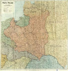
Title: Mapa Polski
Creator:
Pokorny, Wilhelm (1881–1928) : oprac. ; Tomaszewski, Adam (1895–1945) : oprac. ; Kaiserlich-Königliches Militär-Geographisches Institut (Wiedeń)
Date issued/created:
Resource type:
Contributor:
Tomaszewski, Adam (1895–1945) : oprac. ; Kaiserlich-Königliches Militär-Geographisches Institut (Wiedeń)
Publisher:
Nakład Księgarni Polskiej Bernarda Połonieckiego
Place of publishing:
Description:
1 map : col. ; 83x80 cm ; Scale 1:1 500 000 ; Prime meridian Ferro ; Projected voivodeships borders and The Upper Silesian plebiscite region are marked ; Dated according to legend details
Detailed Resource Type:
Format:
Resource Identifier:
Source:
CBGiOŚ. IGiPZ PAN, call no. PTG D.674 [m.polit.-adm.60] ; click here to follow the link
Language:
Rights:
Terms of use:
Digitizing institution:
Institute of Geography and Spatial Organization of the Polish Academy of Sciences
Original in:
Projects co-financed by:
Programme Innovative Economy, 2010-2014, Priority Axis 2. R&D infrastructure ; European Union. European Regional Development Fund
Access:
Object collections:
- Digital Repository of Scientific Institutes > Partners' collections > Institute of Geography and Spatial Organization PAS (IGiPZ PAN) > Library
- Digital Repository of Scientific Institutes > Partners' collections > Institute of Geography and Spatial Organization PAS (IGiPZ PAN) > Library > Maps and atlases
- Digital Repository of Scientific Institutes > Partners' collections > Institute of Geography and Spatial Organization PAS (IGiPZ PAN) > Library > Selected collections > Polish Geographical Society Collection
- Digital Repository of Scientific Institutes > Literature > Maps/Atlases
Last modified:
Oct 2, 2020
In our library since:
Aug 5, 2013
Number of object content downloads / hits:
910
All available object's versions:
https://rcin.org.pl./publication/47535
Show description in RDF format:
Show description in RDFa format:
Show description in OAI-PMH format:
| Edition name | Date |
|---|---|
| Mapa Polski, [1919] | Oct 2, 2020 |
Objects Similar
Tomaszewski, Adam (1895–1945) Kaiserlich-Königliches Militär-Geographisches Institut (Wiedeń)
Kaiserlich-Königliches Militär-Geographisches Institut (Wiedeń)
Korbel, Stanisław (1882–1956) Sawicki, Ludomir (1884–1928) Księgarnia Geograficzna "Orbis"
Kaiserlich-Königliches Militär-Geographisches Institut (Wiedeń)
Kaiserlich-Königliches Militär-Geographisches Institut (Wiedeń)
Langner, Paweł Lejczak, Józef Ossoliński, Kazimierz Kucharski, Władysław Wydawnictwo Księgarni H. Altenberga (Lwów)

 INSTYTUT ARCHEOLOGII I ETNOLOGII POLSKIEJ AKADEMII NAUK
 INSTYTUT BADAŃ LITERACKICH POLSKIEJ AKADEMII NAUK
 INSTYTUT BADAWCZY LEŚNICTWA
 INSTYTUT BIOLOGII DOŚWIADCZALNEJ IM. MARCELEGO NENCKIEGO POLSKIEJ AKADEMII NAUK
 INSTYTUT BIOLOGII SSAKÓW POLSKIEJ AKADEMII NAUK
 INSTYTUT CHEMII FIZYCZNEJ PAN
 INSTYTUT CHEMII ORGANICZNEJ PAN
 INSTYTUT FILOZOFII I SOCJOLOGII PAN
 INSTYTUT GEOGRAFII I PRZESTRZENNEGO ZAGOSPODAROWANIA PAN
 INSTYTUT HISTORII im. TADEUSZA MANTEUFFLA POLSKIEJ AKADEMII NAUK
 INSTYTUT JĘZYKA POLSKIEGO POLSKIEJ AKADEMII NAUK
 INSTYTUT MATEMATYCZNY PAN
 INSTYTUT MEDYCYNY DOŚWIADCZALNEJ I KLINICZNEJ IM.MIROSŁAWA MOSSAKOWSKIEGO POLSKIEJ AKADEMII NAUK
 INSTYTUT PODSTAWOWYCH PROBLEMÓW TECHNIKI PAN
 INSTYTUT SLAWISTYKI PAN
 SIEĆ BADAWCZA ŁUKASIEWICZ - INSTYTUT TECHNOLOGII MATERIAŁÓW ELEKTRONICZNYCH
 MUZEUM I INSTYTUT ZOOLOGII POLSKIEJ AKADEMII NAUK
 INSTYTUT BADAŃ SYSTEMOWYCH PAN
 INSTYTUT BOTANIKI IM. WŁADYSŁAWA SZAFERA POLSKIEJ AKADEMII NAUK


