- Search in all Repository
- Literature and maps
- Archeology
- Mills database
- Natural sciences
Advanced search
Advanced search
Advanced search
Advanced search
Advanced search

Object
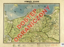
Title: Wybrzeże polskie : mapa fizyczna
Creator:
Krygowski, Bogumił (1905–1977) : Oprac. ; Drukarnia i Księgarnia Św. Wojciecha
Date issued/created:
Resource type:
Publisher:
Nakładem Drukarni św. Wojciecha P.Z.P. ; (Offset Drukarni św. Wojciecha pod Zarządem Państw.)
Place of publishing:
Description:
Scale 1:1 200 000 ; 1 map : col. ; 28x39 cm, on sheet 34x48 cm ; Ancillary map: Wyspa Rugia ; Under bottom neat line: schematic administrative division of NW Poland according to 7th July 1945 ; Dated according to: BNPol online
Detailed Resource Type:
Format:
Resource Identifier:
Source:
CBGiOŚ. IGiPZ PAN, call no. PAN D.5367 [m.ogóln.16] ; click here to follow the link
Language:
Rights:
Rights Reserved - Restricted Access
Terms of use:
Digitizing institution:
Institute of Geography and Spatial Organization of the Polish Academy of Sciences
Original in:
Projects co-financed by:
Programme Innovative Economy, 2010-2014, Priority Axis 2. R&D infrastructure ; European Union. European Regional Development Fund
Access:
Object collections:
- Digital Repository of Scientific Institutes > Partners' collections > Institute of Geography and Spatial Organization PAS (IGiPZ PAN) > Library
- Digital Repository of Scientific Institutes > Partners' collections > Institute of Geography and Spatial Organization PAS (IGiPZ PAN) > Library > Maps and atlases
- Digital Repository of Scientific Institutes > Literature > Maps/Atlases
Last modified:
Oct 2, 2020
In our library since:
Jun 20, 2013
Number of object content downloads / hits:
53
All available object's versions:
https://rcin.org.pl./publication/44662
Show description in RDF format:
Show description in RDFa format:
Show description in OAI-PMH format:
| Edition name | Date |
|---|---|
| Wybrzeże polskie : mapa fizyczna, [1945] | Oct 2, 2020 |
Objects Similar
Ułaszynówna, Zofia. Księgarnia św. Wojciecha Drukarnia i Księgarnia św. Wojciecha
Trzebiński, Józef (1867–1941) Księgarnia św. Wojciecha (Poznań) Drukarnia i Księgarnia św. Wojciecha (Poznań)
Jeske-Choiński, Teodor (1854–1920) Księgarnia św. Wojciecha Drukarnia i Księgarnia św. Wojciecha
Hoesick, Ferdynand (1867–1941) Drukarnia i Księgarnia św. Wojciecha
Plater-Broel, Ludwika (1821–1897) Drukarnia i Księgarnia św. Wojciecha
Snowacki, Antoni (1876– ) Drukarnia i Księgarnia św. Wojciecha
Węckowski, Stanisław (1876–1937) Drukarnia i Księgarnia św. Wojciecha
Okoniewski, Stanisław Wojciech (1870–1944) Drukarnia i Księgarnia św. Wojciecha

 INSTYTUT ARCHEOLOGII I ETNOLOGII POLSKIEJ AKADEMII NAUK
 INSTYTUT BADAŃ LITERACKICH POLSKIEJ AKADEMII NAUK
 INSTYTUT BADAWCZY LEŚNICTWA
 INSTYTUT BIOLOGII DOŚWIADCZALNEJ IM. MARCELEGO NENCKIEGO POLSKIEJ AKADEMII NAUK
 INSTYTUT BIOLOGII SSAKÓW POLSKIEJ AKADEMII NAUK
 INSTYTUT CHEMII FIZYCZNEJ PAN
 INSTYTUT CHEMII ORGANICZNEJ PAN
 INSTYTUT FILOZOFII I SOCJOLOGII PAN
 INSTYTUT GEOGRAFII I PRZESTRZENNEGO ZAGOSPODAROWANIA PAN
 INSTYTUT HISTORII im. TADEUSZA MANTEUFFLA POLSKIEJ AKADEMII NAUK
 INSTYTUT JĘZYKA POLSKIEGO POLSKIEJ AKADEMII NAUK
 INSTYTUT MATEMATYCZNY PAN
 INSTYTUT MEDYCYNY DOŚWIADCZALNEJ I KLINICZNEJ IM.MIROSŁAWA MOSSAKOWSKIEGO POLSKIEJ AKADEMII NAUK
 INSTYTUT PODSTAWOWYCH PROBLEMÓW TECHNIKI PAN
 INSTYTUT SLAWISTYKI PAN
 SIEĆ BADAWCZA ŁUKASIEWICZ - INSTYTUT TECHNOLOGII MATERIAŁÓW ELEKTRONICZNYCH
 MUZEUM I INSTYTUT ZOOLOGII POLSKIEJ AKADEMII NAUK
 INSTYTUT BADAŃ SYSTEMOWYCH PAN
 INSTYTUT BOTANIKI IM. WŁADYSŁAWA SZAFERA POLSKIEJ AKADEMII NAUK


