- Search in all Repository
- Literature and maps
- Archeology
- Mills database
- Natural sciences
Advanced search
Advanced search
Advanced search
Advanced search
Advanced search

Object
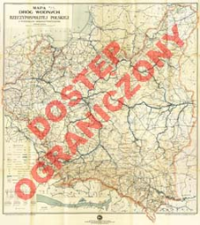
Title: Mapa dróg wodnych Rzeczypospolitej Polskiej z podziałem administracyjnym
Subtitle:
Mapa dróg i turystyki wodnej Rzeczypospolitej Polskiej : podziałka 1:1.000.000
Contributor:
Wacznadze, D. : Oprac. (kartograf) ; Kołodziejski, Czesław : Oprac. ; Centrala Sprzedaży Map Koziej, Olszewski i Filipowicz ; Polski Touring Klub. Sekcja Yachtingu Motorowego
Publisher:
Centrala Sprzedaży Map Koziej, Olszewski i Filipowicz ; (Zakł. Kart. W. Cukrzyński, S. Goliński i S-ka)
Place of publishing:
Description:
Scale 1:1 000 000 ; 1 map : col. ; ark. 96x85 cm, folded to 23x15 cm + text: 56, [10] p. ; 24x17 cm ; Contents of appendix.: advertisements, alphabetical index of rivers, canals and lakes, water regulations and signs, alphabetical water dictionary ; On the ancillary map in scale 1:30 000 Vistula route with marinas, sailing clubs and bridges. Under the map legend: Schemat organizacji urzędów wodnych [w Polsce] ; Date of edition from the advertisement of appendix (p. 7) ; Geographical names on the map in Polish, partly in German
Detailed Resource Type:
Format:
Resource Identifier:
Source:
CBGiOŚ. IGiPZ PAN, call no. D.1828[1-2] [m.hydrogr.2] ; CBGiOŚ. IGiPZ PAN, call no. D.12673[1] [m.hydrogr.1] ; click here to follow the link
Language:
Rights:
Rights Reserved - Restricted Access
Terms of use:
Digitizing institution:
Institute of Geography and Spatial Organization of the Polish Academy of Sciences
Original in:
Projects co-financed by:
Programme Innovative Economy, 2010-2014, Priority Axis 2. R&D infrastructure ; European Union. European Regional Development Fund
Access:
Object collections:
- Digital Repository of Scientific Institutes > Partners' collections > Institute of Geography and Spatial Organization PAS (IGiPZ PAN) > Library
- Digital Repository of Scientific Institutes > Partners' collections > Institute of Geography and Spatial Organization PAS (IGiPZ PAN) > Library > Books
- Digital Repository of Scientific Institutes > Partners' collections > Institute of Geography and Spatial Organization PAS (IGiPZ PAN) > Library > Maps and atlases
- Digital Repository of Scientific Institutes > Literature > Maps/Atlases
Last modified:
Oct 2, 2020
In our library since:
Apr 18, 2013
Number of object content downloads / hits:
206
All available object's versions:
https://rcin.org.pl./publication/44196
Show description in RDF format:
Show description in RDFa format:
Show description in OAI-PMH format:
| Edition name | Date |
|---|---|
| Wacznadze, D. (kartograf). Oprac., [ca 1938], Mapa dróg wodnych Rzeczypospolitej Polskiej z podziałem administracyjnym | Oct 2, 2020 |
Objects Similar
Niemcy. Heer. Generalstab. Abteilung für Kriegskarten und Vermessungswesen. Wydawca
Gea Verlag. Wydawca Berliner Lithographisches Institut. Wydawca
Instytut Wojskowo-Geograficzny (Warszawa). Wydawca Zakłady Graficzne B. Wierzbicki i Spółka. Drukarz

 INSTYTUT ARCHEOLOGII I ETNOLOGII POLSKIEJ AKADEMII NAUK
 INSTYTUT BADAŃ LITERACKICH POLSKIEJ AKADEMII NAUK
 INSTYTUT BADAWCZY LEŚNICTWA
 INSTYTUT BIOLOGII DOŚWIADCZALNEJ IM. MARCELEGO NENCKIEGO POLSKIEJ AKADEMII NAUK
 INSTYTUT BIOLOGII SSAKÓW POLSKIEJ AKADEMII NAUK
 INSTYTUT CHEMII FIZYCZNEJ PAN
 INSTYTUT CHEMII ORGANICZNEJ PAN
 INSTYTUT FILOZOFII I SOCJOLOGII PAN
 INSTYTUT GEOGRAFII I PRZESTRZENNEGO ZAGOSPODAROWANIA PAN
 INSTYTUT HISTORII im. TADEUSZA MANTEUFFLA POLSKIEJ AKADEMII NAUK
 INSTYTUT JĘZYKA POLSKIEGO POLSKIEJ AKADEMII NAUK
 INSTYTUT MATEMATYCZNY PAN
 INSTYTUT MEDYCYNY DOŚWIADCZALNEJ I KLINICZNEJ IM.MIROSŁAWA MOSSAKOWSKIEGO POLSKIEJ AKADEMII NAUK
 INSTYTUT PODSTAWOWYCH PROBLEMÓW TECHNIKI PAN
 INSTYTUT SLAWISTYKI PAN
 SIEĆ BADAWCZA ŁUKASIEWICZ - INSTYTUT TECHNOLOGII MATERIAŁÓW ELEKTRONICZNYCH
 MUZEUM I INSTYTUT ZOOLOGII POLSKIEJ AKADEMII NAUK
 INSTYTUT BADAŃ SYSTEMOWYCH PAN
 INSTYTUT BOTANIKI IM. WŁADYSŁAWA SZAFERA POLSKIEJ AKADEMII NAUK


