- About project
- Collections
- Indexes
- Recently viewed
-
RCIN Repositories
-
 INSTYTUT ARCHEOLOGII I ETNOLOGII POLSKIEJ AKADEMII NAUK
-
 INSTYTUT BADAŃ LITERACKICH POLSKIEJ AKADEMII NAUK
-
 INSTYTUT BADAWCZY LEŚNICTWA
-
 INSTYTUT BIOLOGII DOŚWIADCZALNEJ IM. MARCELEGO NENCKIEGO POLSKIEJ AKADEMII NAUK
-
 INSTYTUT BIOLOGII SSAKÓW POLSKIEJ AKADEMII NAUK
-
 INSTYTUT CHEMII FIZYCZNEJ PAN
-
 INSTYTUT CHEMII ORGANICZNEJ PAN
-
 INSTYTUT FILOZOFII I SOCJOLOGII PAN
-
 INSTYTUT GEOGRAFII I PRZESTRZENNEGO ZAGOSPODAROWANIA PAN
-
 INSTYTUT HISTORII im. TADEUSZA MANTEUFFLA POLSKIEJ AKADEMII NAUK
-
 INSTYTUT JĘZYKA POLSKIEGO POLSKIEJ AKADEMII NAUK
-
 INSTYTUT MATEMATYCZNY PAN
-
 INSTYTUT MEDYCYNY DOŚWIADCZALNEJ I KLINICZNEJ IM.MIROSŁAWA MOSSAKOWSKIEGO POLSKIEJ AKADEMII NAUK
-
 INSTYTUT PODSTAWOWYCH PROBLEMÓW TECHNIKI PAN
-
 INSTYTUT SLAWISTYKI PAN
-
 SIEĆ BADAWCZA ŁUKASIEWICZ - INSTYTUT TECHNOLOGII MATERIAŁÓW ELEKTRONICZNYCH
-
 MUZEUM I INSTYTUT ZOOLOGII POLSKIEJ AKADEMII NAUK
-
 INSTYTUT BADAŃ SYSTEMOWYCH PAN
-
 INSTYTUT BOTANIKI IM. WŁADYSŁAWA SZAFERA POLSKIEJ AKADEMII NAUK
-
- Search in all Repository
- Literature and maps
- Archeology
- Mills database
- Natural sciences
Advanced search
Advanced search
Advanced search
Advanced search
Advanced search

Object
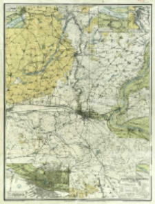
Title: Mapa powiatu bydgoskiego w podziałce 1:100 000
Contributor:
Publisher:
nakładem Spółki Pedagogicznej T.A.
Place of publishing:
Description:
Scale 1:100 000 ; 1 map :col. ; 67x51 cm, on sheet 72x56 cm ; Ancillary maps: Plan szczegółowy m. Solca w podziałce 1:25 000, Plan szczegółowy m. Koronowa w podziałce 1:25 000, Plan szczegółowy miasta Fordonu w podziałce 1:25 000, Plan szczegółowy miasta Bydgoszczy w podziałce 1:25 000 ; Date of publication based on contents of the map: administrative boundary after 1918, lack of railway lines opened after 1928 year ; Prime meridian Ferro
Detailed Resource Type:
Format:
Resource Identifier:
Source:
CBGiOŚ. IGiPZ PAN, call no. D.4159 [m.ogólnog.2] ; click here to follow the link
Language:
Rights:
Terms of use:
Digitizing institution:
Institute of Geography and Spatial Organization of the Polish Academy of Sciences
Original in:
Projects co-financed by:
Programme Innovative Economy, 2010-2014, Priority Axis 2. R&D infrastructure ; European Union. European Regional Development Fund
Access:
Object collections:
- Digital Repository of Scientific Institutes > Partners' collections > Institute of Geography and Spatial Organization PAS (IGiPZ PAN) > Library
- Digital Repository of Scientific Institutes > Partners' collections > Institute of Geography and Spatial Organization PAS (IGiPZ PAN) > Library > Maps and atlases
- Digital Repository of Scientific Institutes > Literature > Maps/Atlases
Last modified:
Oct 2, 2020
In our library since:
May 14, 2013
Number of object content downloads / hits:
279
All available object's versions:
https://rcin.org.pl./publication/43831
Show description in RDF format:
Show description in RDFa format:
Show description in OAI-PMH format:
| Edition name | Date |
|---|---|
| Łabendziński, Stanisław (1880-1933), [ca 1918-1928], Mapa powiatu bydgoskiego w podziałce 1:100 000 | Oct 2, 2020 |
Objects Similar
Instytut Wojskowo-Geograficzny (Warszawa). Wydawca. Drukarz
Wojskowy Instytut Geograficzny (Warszawa). Wydawca. Drukarz
Prusy. Landesaufnahme. Kartographische Abteilung. Redaktor
Polska. Wojsko Polskie (1918 - 1939). Sztab Generalny. Instytucja sprawcza. Wydawca
Dokaupil, Roman (18...- 19...). Redaktor Straka, J. Redaktor Bloschitz, Rudolf Macoun, V. Redaktor
Wojskowy Instytut Geograficzny (Warszawa). Wydawca. Drukarz
Niemcy. Grosser Generalstab. Kartographische Abteilung. Redaktor


