- About project
- Collections
- Indexes
- Recently viewed
-
RCIN Repositories
-
 INSTYTUT ARCHEOLOGII I ETNOLOGII POLSKIEJ AKADEMII NAUK
-
 INSTYTUT BADAŃ LITERACKICH POLSKIEJ AKADEMII NAUK
-
 INSTYTUT BADAWCZY LEŚNICTWA
-
 INSTYTUT BIOLOGII DOŚWIADCZALNEJ IM. MARCELEGO NENCKIEGO POLSKIEJ AKADEMII NAUK
-
 INSTYTUT BIOLOGII SSAKÓW POLSKIEJ AKADEMII NAUK
-
 INSTYTUT CHEMII FIZYCZNEJ PAN
-
 INSTYTUT CHEMII ORGANICZNEJ PAN
-
 INSTYTUT FILOZOFII I SOCJOLOGII PAN
-
 INSTYTUT GEOGRAFII I PRZESTRZENNEGO ZAGOSPODAROWANIA PAN
-
 INSTYTUT HISTORII im. TADEUSZA MANTEUFFLA POLSKIEJ AKADEMII NAUK
-
 INSTYTUT JĘZYKA POLSKIEGO POLSKIEJ AKADEMII NAUK
-
 INSTYTUT MATEMATYCZNY PAN
-
 INSTYTUT MEDYCYNY DOŚWIADCZALNEJ I KLINICZNEJ IM.MIROSŁAWA MOSSAKOWSKIEGO POLSKIEJ AKADEMII NAUK
-
 INSTYTUT PODSTAWOWYCH PROBLEMÓW TECHNIKI PAN
-
 INSTYTUT SLAWISTYKI PAN
-
 SIEĆ BADAWCZA ŁUKASIEWICZ - INSTYTUT TECHNOLOGII MATERIAŁÓW ELEKTRONICZNYCH
-
 MUZEUM I INSTYTUT ZOOLOGII POLSKIEJ AKADEMII NAUK
-
 INSTYTUT BADAŃ SYSTEMOWYCH PAN
-
 INSTYTUT BOTANIKI IM. WŁADYSŁAWA SZAFERA POLSKIEJ AKADEMII NAUK
-
- Search in all Repository
- Literature and maps
- Archeology
- Mills database
- Natural sciences
Advanced search
Advanced search
Advanced search
Advanced search
Advanced search

Object
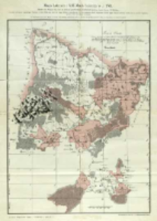
Title: Mapa Lubowli i XIII Miast Spiskich w r. 1769 = Skelet zur Mappa von der an Pohlen gepfändeten Herrschaft Lublau nebst denen 13 Städten
Subtitle:
Skelet zur Mappa von der an Pohlen gepfändeten Herrschaft Lublau nebst denen 13 Städten
Contributor:
Kaiserlich-Königliches Militär-Geographisches Institut (Wiedeń)
Publisher:
Photolithographie und Druck des k. u. k. militär-geographischen Institutes
Place of publishing:
Description:
[Skala ca 1:172 000] ; 1 mapa : fotolitogr. kolor. ; 48x136cm, na ark. 63x47 cm ; Tyt. znad ramki mapy ; Nad ramką pod tyt. i legendą: Auf Allerhöchsten kays. königl. Befehl. im sommer 1769 geometrice aufgenommen unter der Direction des Obristlieutenants Br. Seeger von Durrenberg vom grossen Generalstab ; Rzeźba terenu przedst. za pomocą metody kopczykowej ; W lewym dolnym rogu pod ramką mapy: "K. und k. Kriegs-Archiv. Ungarn. - Aufnahmen. - Arch. Nr. 1."; W prawym dolnym rogu pod ramką mapy: Photolithographie und Druck des k. u. k. militär-geographischen Institutes ; BNPol online ; Tyt. w jęz. niem. i pol., legenda i treść mapy w jęz. niem.
Detailed Resource Type:
Format:
Resource Identifier:
Source:
CBGiOŚ. IGiPZ PAN, call no. D.6478 [m.hist.46] ; click here to follow the link
Language:
Rights:
Terms of use:
Digitizing institution:
Institute of Geography and Spatial Organization of the Polish Academy of Sciences
Original in:
Projects co-financed by:
Programme Innovative Economy, 2010-2014, Priority Axis 2. R&D infrastructure ; European Union. European Regional Development Fund
Access:
Object collections:
- Digital Repository of Scientific Institutes > Partners' collections > Institute of Geography and Spatial Organization PAS (IGiPZ PAN) > Library
- Digital Repository of Scientific Institutes > Partners' collections > Institute of Geography and Spatial Organization PAS (IGiPZ PAN) > Library > Maps and atlases
- Digital Repository of Scientific Institutes > Literature > Maps/Atlases
Last modified:
Oct 2, 2020
In our library since:
Jun 13, 2013
Number of object content downloads / hits:
185
All available object's versions:
https://rcin.org.pl./publication/41542
Show description in RDF format:
Show description in RDFa format:
Show description in OAI-PMH format:
Objects Similar
Bończa-Tomaszewski, Stanisław (1861–1935)
Gostyński, Władysław Bazewicz, Józef Michał (c. 1862 – 1928) Litografia Artystyczna W. Główczewski (Warszawa)


