- O repozytorium
- Kolekcje
- Indeksy
- Historia przeglądania
-
Repozytoria RCIN
-
 INSTYTUT ARCHEOLOGII I ETNOLOGII POLSKIEJ AKADEMII NAUK
-
 INSTYTUT BADAŃ LITERACKICH POLSKIEJ AKADEMII NAUK
-
 INSTYTUT BADAWCZY LEŚNICTWA
-
 INSTYTUT BIOLOGII DOŚWIADCZALNEJ IM. MARCELEGO NENCKIEGO POLSKIEJ AKADEMII NAUK
-
 INSTYTUT BIOLOGII SSAKÓW POLSKIEJ AKADEMII NAUK
-
 INSTYTUT CHEMII FIZYCZNEJ PAN
-
 INSTYTUT CHEMII ORGANICZNEJ PAN
-
 INSTYTUT FILOZOFII I SOCJOLOGII PAN
-
 INSTYTUT GEOGRAFII I PRZESTRZENNEGO ZAGOSPODAROWANIA PAN
-
 INSTYTUT HISTORII im. TADEUSZA MANTEUFFLA POLSKIEJ AKADEMII NAUK
-
 INSTYTUT JĘZYKA POLSKIEGO POLSKIEJ AKADEMII NAUK
-
 INSTYTUT MATEMATYCZNY PAN
-
 INSTYTUT MEDYCYNY DOŚWIADCZALNEJ I KLINICZNEJ IM.MIROSŁAWA MOSSAKOWSKIEGO POLSKIEJ AKADEMII NAUK
-
 INSTYTUT PODSTAWOWYCH PROBLEMÓW TECHNIKI PAN
-
 INSTYTUT SLAWISTYKI PAN
-
 SIEĆ BADAWCZA ŁUKASIEWICZ - INSTYTUT TECHNOLOGII MATERIAŁÓW ELEKTRONICZNYCH
-
 MUZEUM I INSTYTUT ZOOLOGII POLSKIEJ AKADEMII NAUK
-
 INSTYTUT BADAŃ SYSTEMOWYCH PAN
-
 INSTYTUT BOTANIKI IM. WŁADYSŁAWA SZAFERA POLSKIEJ AKADEMII NAUK
-
- Wyszukaj w całym Repozytorium
- Piśmiennictwo i mapy
- Archeologia
- Baza Młynów
- Nauki przyrodnicze
Wyszukiwanie zaawansowane
Wyszukiwanie zaawansowane
Wyszukiwanie zaawansowane
Wyszukiwanie zaawansowane
Wyszukiwanie zaawansowane

Obiekt
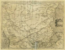
Tytuł: Evropae Tabvla. IX. Continet Iazyges Metanastas Daciam Mysiam superiorem, Mysiam inferiorem, & Thraciam
Inny tytuł:
Europae Tabula IX ; Evr: IX Tab
Współtwórca:
Mercator, Gerard (1512–1594) : Oprac. ; Kempen, Gottfried von (15..-1598?). Druk.
Wydawca:
Miejsce wydania:
Opis:
Skala [ca 1:2 700 000] ; 1 mapa : miedzior. ; 35x45 cm ; Rzeźba terenu przedst. metodą kopczykową ; Mapa pochodzi z atlasu: Tabvlae Geographicae Cl. Ptolem[aei] ad mentem autoris restitutae & emendatae / per Gerardum Mercatorem iIlustriss: ducis Cliui[ae] etc: Cosmographu[m], wydawanym przez Gotfrieda von Kempena w roku 1578 i 1584] ; Na odwrocie k. opis współrzędnych poszczególnych terenów
Szczegółowy typ zasobu:
Format:
Identyfikator zasobu:
Źródło:
CBGiOŚ. IGiPZ PAN, sygn. B.KS.448/1 ; kliknij tutaj, żeby przejść
Język:
Prawa:
Zasady wykorzystania:
Digitalizacja:
Instytut Geografii i Przestrzennego Zagospodarowania Polskiej Akademii Nauk
Lokalizacja oryginału:
Dofinansowane ze środków:
Program Operacyjny Innowacyjna Gospodarka, lata 2010-2014, Priorytet 2. Infrastruktura strefy B + R ; Unia Europejska. Europejski Fundusz Rozwoju Regionalnego
Dostęp:
Kolekcje, do których przypisany jest obiekt:
- Repozytorium Cyfrowe Instytutów Naukowych > Kolekcje Partnerów > Instytut Geografii i Przestrzennego Zagospodarowania PAN > Biblioteka Instytutu
- Repozytorium Cyfrowe Instytutów Naukowych > Kolekcje Partnerów > Instytut Geografii i Przestrzennego Zagospodarowania PAN > Biblioteka Instytutu > Mapy i atlasy
- Repozytorium Cyfrowe Instytutów Naukowych > Kolekcje Partnerów > Instytut Geografii i Przestrzennego Zagospodarowania PAN > Biblioteka Instytutu > Wybrane księgozbiory > Księgozbiór Polskiego Towarzystwa Geograficznego
- Repozytorium Cyfrowe Instytutów Naukowych > Kolekcje Partnerów > Instytut Geografii i Przestrzennego Zagospodarowania PAN > Biblioteka Instytutu > Wybrane księgozbiory > Księgozbiór Prof. Józefa Staszewskiego
- Repozytorium Cyfrowe Instytutów Naukowych > Piśmiennictwo > Mapy/Atlasy
Data ostatniej modyfikacji:
2 paź 2020
Data dodania obiektu:
9 paź 2013
Liczba pobrań / odtworzeń:
164
Wszystkie dostępne wersje tego obiektu:
https://rcin.org.pl./publication/39534
Wyświetl opis w formacie RDF:
Wyświetl opis w formacie RDFa:
Wyświetl opis w formacie OAI-PMH:
| Nazwa wydania | Data |
|---|---|
| Ptolemaeus, Claudius (ca 100-ca 178), [ca 1584], Evropae Tabvla IX | 2 paź 2020 |
Obiekty Podobne
Ptolemaeus, Claudius (c. 100 – c. 178)
Ptolemaeus, Claudius (c. 100 – c. 178)
Ptolemaeus, Claudius (c. 100 – c. 178) Münster, Sebastian (1489–1552) Pirckheimer, Willibald (1470–1530) Petri, Heinrich (1508–1579)
Ptolemaeus, Claudius (c. 100 – c. 178) Kempen, Gottfried von (15..-1598?). Wyd. Mercator, Gerard (1512–1594)
Ptolemaeus, Claudius (c. 100 – c. 178) Pirckheimer, Willibald (1470–1530) Regiomontanus, Johannes (1436–1476) Jacobus Angelus de Scarperia. Tł. Grüninger, Johannes (1455–1532) Koberger, Johannes (1454?-1543)
Jode, Cornelis de (1568–1600)


