- About project
- Collections
- Indexes
- Recently viewed
-
RCIN Repositories
-
 INSTYTUT ARCHEOLOGII I ETNOLOGII POLSKIEJ AKADEMII NAUK
-
 INSTYTUT BADAŃ LITERACKICH POLSKIEJ AKADEMII NAUK
-
 INSTYTUT BADAWCZY LEŚNICTWA
-
 INSTYTUT BIOLOGII DOŚWIADCZALNEJ IM. MARCELEGO NENCKIEGO POLSKIEJ AKADEMII NAUK
-
 INSTYTUT BIOLOGII SSAKÓW POLSKIEJ AKADEMII NAUK
-
 INSTYTUT CHEMII FIZYCZNEJ PAN
-
 INSTYTUT CHEMII ORGANICZNEJ PAN
-
 INSTYTUT FILOZOFII I SOCJOLOGII PAN
-
 INSTYTUT GEOGRAFII I PRZESTRZENNEGO ZAGOSPODAROWANIA PAN
-
 INSTYTUT HISTORII im. TADEUSZA MANTEUFFLA POLSKIEJ AKADEMII NAUK
-
 INSTYTUT JĘZYKA POLSKIEGO POLSKIEJ AKADEMII NAUK
-
 INSTYTUT MATEMATYCZNY PAN
-
 INSTYTUT MEDYCYNY DOŚWIADCZALNEJ I KLINICZNEJ IM.MIROSŁAWA MOSSAKOWSKIEGO POLSKIEJ AKADEMII NAUK
-
 INSTYTUT PODSTAWOWYCH PROBLEMÓW TECHNIKI PAN
-
 INSTYTUT SLAWISTYKI PAN
-
 SIEĆ BADAWCZA ŁUKASIEWICZ - INSTYTUT TECHNOLOGII MATERIAŁÓW ELEKTRONICZNYCH
-
 MUZEUM I INSTYTUT ZOOLOGII POLSKIEJ AKADEMII NAUK
-
 INSTYTUT BADAŃ SYSTEMOWYCH PAN
-
 INSTYTUT BOTANIKI IM. WŁADYSŁAWA SZAFERA POLSKIEJ AKADEMII NAUK
-
- Search in all Repository
- Literature and maps
- Archeology
- Mills database
- Natural sciences
Advanced search
Advanced search
Advanced search
Advanced search
Advanced search

Object
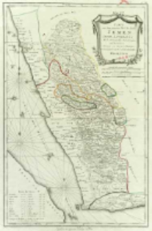
Title: Karte von dem groessten Theil des Landes Jemen Imame, Kaukeban &. &.. : Nach astronomischen Beobachtungen, und Reisemaassen
Contributor:
Schraembl, Franz Anton (1751–1803) : Wyd.
Publisher:
Place of publishing:
Description:
Skala [ca 1:1 200 000], podziałka Deutsche oder geographische Meilen, Franzoesische Meilen ; 1 mapa : miedzior., kolor. ręcznie ; 57x37 cm ; Rzeźba terenu przedst. metodą kreskową ; Południk zerowy Paryż ; Pod ramką: Zufinden in eigenen Verlage in Wien ; Miejsce wyd. wg. wydawcy ; Podano szer.geogr. ważniejszych miejscowości ; Na obszarze Morza Czerwonego umieszczono trzy 32-dwu rumbowe róże wiatrów ; Kolorem zaznaczono graniceadministracyjne ; Na mapie data: MDCCLXXXIX
Detailed Resource Type:
Format:
Resource Identifier:
Source:
CBGiOŚ. IGiPZ PAN, call no. Ds.8155 ; click here to follow the link
Language:
Rights:
Terms of use:
Digitizing institution:
Institute of Geography and Spatial Organization of the Polish Academy of Sciences
Original in:
Projects co-financed by:
Programme Innovative Economy, 2010-2014, Priority Axis 2. R&D infrastructure ; European Union. European Regional Development Fund
Access:
Object collections:
- Digital Repository of Scientific Institutes > Partners' collections > Institute of Geography and Spatial Organization PAS (IGiPZ PAN) > Library
- Digital Repository of Scientific Institutes > Partners' collections > Institute of Geography and Spatial Organization PAS (IGiPZ PAN) > Library > Maps and atlases
- Digital Repository of Scientific Institutes > Literature > Maps/Atlases
Last modified:
Oct 2, 2020
In our library since:
May 14, 2013
Number of object content downloads / hits:
62
All available object's versions:
https://rcin.org.pl./publication/38420
Show description in RDF format:
Show description in RDFa format:
Show description in OAI-PMH format:
Objects Similar
Delisle, Guillaume (1675–1726) Buache, Philippe (1700–1773)
Sotzmann, Daniel Fridrich (1754–1840) Penningh, Harry John Glassbach, Carl Christian (1751-post 1791) Schmidt, Friedrich August Sander, Wilhelm (c. 1766 – 1836)
Güssefeld, Franz Ludwig (1744–1808)
Müller, Franz (1755–1816) Schütz, Carl (1745–1800)
Delisle, Guillaume (1675–1726) Condet, Johannes (1711–1781)
Morden. Robert (?-1703) Browne, Christopher (fl. 1684-1712) Harris, J.


