- About project
- Collections
- Indexes
- Recently viewed
-
RCIN Repositories
-
 INSTYTUT ARCHEOLOGII I ETNOLOGII POLSKIEJ AKADEMII NAUK
-
 INSTYTUT BADAŃ LITERACKICH POLSKIEJ AKADEMII NAUK
-
 INSTYTUT BADAWCZY LEŚNICTWA
-
 INSTYTUT BIOLOGII DOŚWIADCZALNEJ IM. MARCELEGO NENCKIEGO POLSKIEJ AKADEMII NAUK
-
 INSTYTUT BIOLOGII SSAKÓW POLSKIEJ AKADEMII NAUK
-
 INSTYTUT CHEMII FIZYCZNEJ PAN
-
 INSTYTUT CHEMII ORGANICZNEJ PAN
-
 INSTYTUT FILOZOFII I SOCJOLOGII PAN
-
 INSTYTUT GEOGRAFII I PRZESTRZENNEGO ZAGOSPODAROWANIA PAN
-
 INSTYTUT HISTORII im. TADEUSZA MANTEUFFLA POLSKIEJ AKADEMII NAUK
-
 INSTYTUT JĘZYKA POLSKIEGO POLSKIEJ AKADEMII NAUK
-
 INSTYTUT MATEMATYCZNY PAN
-
 INSTYTUT MEDYCYNY DOŚWIADCZALNEJ I KLINICZNEJ IM.MIROSŁAWA MOSSAKOWSKIEGO POLSKIEJ AKADEMII NAUK
-
 INSTYTUT PODSTAWOWYCH PROBLEMÓW TECHNIKI PAN
-
 INSTYTUT SLAWISTYKI PAN
-
 SIEĆ BADAWCZA ŁUKASIEWICZ - INSTYTUT TECHNOLOGII MATERIAŁÓW ELEKTRONICZNYCH
-
 MUZEUM I INSTYTUT ZOOLOGII POLSKIEJ AKADEMII NAUK
-
 INSTYTUT BADAŃ SYSTEMOWYCH PAN
-
 INSTYTUT BOTANIKI IM. WŁADYSŁAWA SZAFERA POLSKIEJ AKADEMII NAUK
-

Object
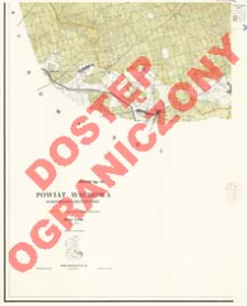
Title: Powiat Wschowa : województwo zielonogórskie : skala 1:25 000
Subtitle:
Mapa Obrębowa Powiatów w Skali 1:25 000. Powiat Wschowa
Publisher:
Zarząd Topograficzny Szt. Gen.
Place of publishing:
Description:
Scale 1:25 000, 1 cm - 250 m ; 1 map on 6 sheets : col. ; each 90x75 cm, complete 169x192 cm ; The processed not-cartometric military map at a scale of 1:25 000 for civil use (Historia Służby Geograficznej i Topograficznej Wojska Polskiego / Eugeniusz Sobczyński. Warszawa, 2000; p. 237) ; Relief shown by contours and spot heights ; No series title on sheets
Relation:
Mapa Obrębowa Powiatów w Skali 1:25 000
Detailed Resource Type:
Format:
Resource Identifier:
Source:
CBGiOŚ. IGiPZ PAN, call no. D.15681[1-6] ; click here to follow the link
Language:
Rights:
Rights Reserved - Restricted Access
Terms of use:
Digitizing institution:
Institute of Geography and Spatial Organization of the Polish Academy of Sciences
Original in:
Projects co-financed by:
Programme Innovative Economy, 2010-2014, Priority Axis 2. R&D infrastructure ; European Union. European Regional Development Fund
Access:
Object collections:
- Digital Repository of Scientific Institutes > Partners' collections > Institute of Geography and Spatial Organization PAS (IGiPZ PAN) > Library
- Digital Repository of Scientific Institutes > Partners' collections > Institute of Geography and Spatial Organization PAS (IGiPZ PAN) > Library > Maps and atlases
- Digital Repository of Scientific Institutes > Literature > Maps/Atlases
Last modified:
Oct 2, 2020
In our library since:
Mar 14, 2013
Number of object content downloads / hits:
32
All available object's versions:
https://rcin.org.pl./publication/36924
Show description in RDF format:
Show description in RDFa format:
Show description in OAI-PMH format:
| Edition name | Date |
|---|---|
| Powiat Wschowa : województwo zielonogórskie : skala 1:25 000, 1961 | Oct 2, 2020 |
Objects Similar
Prusy. Landesaufnahme. Redaktor Niemcy. Reichsamt für Landesaufnahme. Wydawca
Niemcy. Reichsamt für Landesaufnahme. Wydawca Prusy. Landesaufnahme. Redaktor
Karpacz, Emilia
Związek Radziecki. Vooružennye Sily. Generalʹnyj štab.
Bawaria (Niemcy ; land). Topographisches Bureau. Redaktor Niemcy. Hauptvermessungsabteilung XIII. Wydawca


