- About project
- Collections
- Indexes
- Recently viewed
-
RCIN Repositories
-
 INSTYTUT ARCHEOLOGII I ETNOLOGII POLSKIEJ AKADEMII NAUK
-
 INSTYTUT BADAŃ LITERACKICH POLSKIEJ AKADEMII NAUK
-
 INSTYTUT BADAWCZY LEŚNICTWA
-
 INSTYTUT BIOLOGII DOŚWIADCZALNEJ IM. MARCELEGO NENCKIEGO POLSKIEJ AKADEMII NAUK
-
 INSTYTUT BIOLOGII SSAKÓW POLSKIEJ AKADEMII NAUK
-
 INSTYTUT CHEMII FIZYCZNEJ PAN
-
 INSTYTUT CHEMII ORGANICZNEJ PAN
-
 INSTYTUT FILOZOFII I SOCJOLOGII PAN
-
 INSTYTUT GEOGRAFII I PRZESTRZENNEGO ZAGOSPODAROWANIA PAN
-
 INSTYTUT HISTORII im. TADEUSZA MANTEUFFLA POLSKIEJ AKADEMII NAUK
-
 INSTYTUT JĘZYKA POLSKIEGO POLSKIEJ AKADEMII NAUK
-
 INSTYTUT MATEMATYCZNY PAN
-
 INSTYTUT MEDYCYNY DOŚWIADCZALNEJ I KLINICZNEJ IM.MIROSŁAWA MOSSAKOWSKIEGO POLSKIEJ AKADEMII NAUK
-
 INSTYTUT PODSTAWOWYCH PROBLEMÓW TECHNIKI PAN
-
 INSTYTUT SLAWISTYKI PAN
-
 SIEĆ BADAWCZA ŁUKASIEWICZ - INSTYTUT TECHNOLOGII MATERIAŁÓW ELEKTRONICZNYCH
-
 MUZEUM I INSTYTUT ZOOLOGII POLSKIEJ AKADEMII NAUK
-
 INSTYTUT BADAŃ SYSTEMOWYCH PAN
-
 INSTYTUT BOTANIKI IM. WŁADYSŁAWA SZAFERA POLSKIEJ AKADEMII NAUK
-
- Search in all Repository
- Literature and maps
- Archeology
- Mills database
- Natural sciences
Advanced search
Advanced search
Advanced search
Advanced search
Advanced search

Object
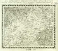
Title: Charte von Mitteleuropa in 64 Sectionen. 46, Des Königreichs Ungarn Mitlerer Östlicher Theile
Subtitle:
Des Königreichs Ungarn Mitlerer Östlicher Theile
Contributor:
Simm, Franz : Oprac. ; Withalm, Andreas (1777–1835) : Ryt.
Publisher:
Place of publishing:
Description:
Skala [ca 1:650 000] ; 1 mapa : miedzior. ; 31x37 cm, ark. 36x41 cm ; Południk zerowy Ferro ; Centralny katalog zbiorów kartograficznych w Polsce, Z. 5, Cz. 1, poz. 51
Relation:
Charte von Mitteleuropa in 64 Sectionen
Detailed Resource Type:
Format:
Resource Identifier:
Source:
CBGiOŚ. IGiPZ PAN, sygn. C.265[34] ; click here to follow the link
Language:
Rights:
Terms of use:
Digitizing institution:
Instytut Geografii i Przestrzennego Zagospodarowania Polskiej Akademii Nauk
Original in:
Projects co-financed by:
Program Operacyjny Innowacyjna Gospodarka, lata 2010-2014, Priorytet 2. Infrastruktura strefy B + R ; Unia Europejska. Europejski Fundusz Rozwoju Regionalnego
Access:
Object collections:
- Digital Repository of Scientific Institutes > Partners' collections > Institute of Geography and Spatial Organization PAS (IGiPZ PAN) > Library
- Digital Repository of Scientific Institutes > Partners' collections > Institute of Geography and Spatial Organization PAS (IGiPZ PAN) > Library > Maps and atlases
- Digital Repository of Scientific Institutes > Literature > Maps/Atlases
Last modified:
Oct 2, 2020
In our library since:
Mar 4, 2013
Number of object content downloads / hits:
70
All available object's versions:
https://rcin.org.pl./publication/33916
Show description in RDF format:
Show description in RDFa format:
Show description in OAI-PMH format:
Objects Similar
Liechtenstern, Joseph Marx von (1765–1828)
Liechtenstern, Joseph Marx von (1765–1828)
Charte von Mitteleuropa in 64 Sectionen. 36, Theile des Königreichs Böhmen u. der Markgrafs. Maehren
Liechtenstern, Joseph Marx von (1765–1828)
Liechtenstern, Joseph Marx von (1765–1828)
Liechtenstern, Joseph Marx von (1765–1828)
Liechtenstern, Joseph Marx von (1765–1828)
Liechtenstern, Joseph Marx von (1765–1828)
Liechtenstern, Joseph Marx von (1765–1828)


