- Search in all Repository
- Literature and maps
- Archeology
- Mills database
- Natural sciences
Advanced search
Advanced search
Advanced search
Advanced search
Advanced search

Object
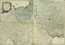
Title: Karta predstavlâûŝaâ Pol'šu i Moldaviû s okolo ležaŝimi zemlâmi
Creator:
Date issued/created:
Resource type:
Institutional creator:
Akademiâ nauk i hudožestv (Petersburg)
Publisher:
Place of publishing:
Description:
Scale [ aprox. 1:740 000] ; 1 map : copperplate engraving, hand col. ; 76x111 cm ; The title cartouche preserves the date of the first issue of the map: 1769. The date of the map between 1774 and 1795 is related to its content: the strip of the Black Sea coast between the lower Dnieper and Bohemia was marked in color as Russian territory (Turkey ceded this area to Russia in 1774), although Bukowina, annexed by Austria in 1775, remains within the borders of Turkey. The map has hand-marked borders and colored the areas of Prussia, Austria and Russia after the peace treaty of Iasi (1792) and the third partition of Poland (1795) ; Prime meridian Ferro established by a cataloguer ; Cited in: CKZKwP. – 2000, Z.6, poz 40
Detailed Resource Type:
Format:
File size 7,6 MB ; image/x.djvu
Resource Identifier:
Source:
CBGiOŚ. IGiPZ PAN, call no. Ds.8070 [I.1B-18] ; click here to follow the link
Language:
Spatial coverage:
Rights:
Terms of use:
Digitizing institution:
Institute of Geography and Spatial Organization of the Polish Academy of Sciences
Original in:
Projects co-financed by:
Programme Innovative Economy, 2010-2014, Priority Axis 2. R&D infrastructure ; European Union. European Regional Development Fund
Access:
Object collections:
- Digital Repository of Scientific Institutes > Partners' collections > Institute of Geography and Spatial Organization PAS (IGiPZ PAN) > Library
- Digital Repository of Scientific Institutes > Partners' collections > Institute of Geography and Spatial Organization PAS (IGiPZ PAN) > Library > Maps and atlases
- Digital Repository of Scientific Institutes > Literature > Maps/Atlases
Last modified:
Dec 12, 2023
In our library since:
Sep 6, 2011
Number of object content downloads / hits:
262
All available object's versions:
https://rcin.org.pl./publication/2971
Show description in RDF format:
Show description in RDFa format:
Show description in OAI-PMH format:
| Edition name | Date |
|---|---|
| Treskot, Johann (1721-1786), 1769, Karta predstavlâûŝaâ Polšu i Moldaviû s okolo ležaŝimi zemlâmi | Dec 12, 2023 |
Objects Similar
Treskot, Johann (1721–1786)
Pfau, Theodor Philipp (1725–1794) Glassbach, Christian Benjamin (1724–1779)
Folino, Bartolomeo (1730 – c. 1808)
Homann, Johann Baptist (1664–1724)
Pfau, Theodor Philipp (1725–1794) Glassbach, Christian Benjamin (1724–1779)
Pfau, Theodor Philipp (1725–1794) Glassbach, Christian Benjamin (1724–1779)

 INSTYTUT ARCHEOLOGII I ETNOLOGII POLSKIEJ AKADEMII NAUK
 INSTYTUT BADAŃ LITERACKICH POLSKIEJ AKADEMII NAUK
 INSTYTUT BADAWCZY LEŚNICTWA
 INSTYTUT BIOLOGII DOŚWIADCZALNEJ IM. MARCELEGO NENCKIEGO POLSKIEJ AKADEMII NAUK
 INSTYTUT BIOLOGII SSAKÓW POLSKIEJ AKADEMII NAUK
 INSTYTUT CHEMII FIZYCZNEJ PAN
 INSTYTUT CHEMII ORGANICZNEJ PAN
 INSTYTUT FILOZOFII I SOCJOLOGII PAN
 INSTYTUT GEOGRAFII I PRZESTRZENNEGO ZAGOSPODAROWANIA PAN
 INSTYTUT HISTORII im. TADEUSZA MANTEUFFLA POLSKIEJ AKADEMII NAUK
 INSTYTUT JĘZYKA POLSKIEGO POLSKIEJ AKADEMII NAUK
 INSTYTUT MATEMATYCZNY PAN
 INSTYTUT MEDYCYNY DOŚWIADCZALNEJ I KLINICZNEJ IM.MIROSŁAWA MOSSAKOWSKIEGO POLSKIEJ AKADEMII NAUK
 INSTYTUT PODSTAWOWYCH PROBLEMÓW TECHNIKI PAN
 INSTYTUT SLAWISTYKI PAN
 SIEĆ BADAWCZA ŁUKASIEWICZ - INSTYTUT TECHNOLOGII MATERIAŁÓW ELEKTRONICZNYCH
 MUZEUM I INSTYTUT ZOOLOGII POLSKIEJ AKADEMII NAUK
 INSTYTUT BADAŃ SYSTEMOWYCH PAN
 INSTYTUT BOTANIKI IM. WŁADYSŁAWA SZAFERA POLSKIEJ AKADEMII NAUK


