- About project
- Collections
- Indexes
- Recently viewed
-
RCIN Repositories
-
 INSTYTUT ARCHEOLOGII I ETNOLOGII POLSKIEJ AKADEMII NAUK
-
 INSTYTUT BADAŃ LITERACKICH POLSKIEJ AKADEMII NAUK
-
 INSTYTUT BADAWCZY LEŚNICTWA
-
 INSTYTUT BIOLOGII DOŚWIADCZALNEJ IM. MARCELEGO NENCKIEGO POLSKIEJ AKADEMII NAUK
-
 INSTYTUT BIOLOGII SSAKÓW POLSKIEJ AKADEMII NAUK
-
 INSTYTUT CHEMII FIZYCZNEJ PAN
-
 INSTYTUT CHEMII ORGANICZNEJ PAN
-
 INSTYTUT FILOZOFII I SOCJOLOGII PAN
-
 INSTYTUT GEOGRAFII I PRZESTRZENNEGO ZAGOSPODAROWANIA PAN
-
 INSTYTUT HISTORII im. TADEUSZA MANTEUFFLA POLSKIEJ AKADEMII NAUK
-
 INSTYTUT JĘZYKA POLSKIEGO POLSKIEJ AKADEMII NAUK
-
 INSTYTUT MATEMATYCZNY PAN
-
 INSTYTUT MEDYCYNY DOŚWIADCZALNEJ I KLINICZNEJ IM.MIROSŁAWA MOSSAKOWSKIEGO POLSKIEJ AKADEMII NAUK
-
 INSTYTUT PODSTAWOWYCH PROBLEMÓW TECHNIKI PAN
-
 INSTYTUT SLAWISTYKI PAN
-
 SIEĆ BADAWCZA ŁUKASIEWICZ - INSTYTUT TECHNOLOGII MATERIAŁÓW ELEKTRONICZNYCH
-
 MUZEUM I INSTYTUT ZOOLOGII POLSKIEJ AKADEMII NAUK
-
 INSTYTUT BADAŃ SYSTEMOWYCH PAN
-
 INSTYTUT BOTANIKI IM. WŁADYSŁAWA SZAFERA POLSKIEJ AKADEMII NAUK
-

Object
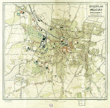
Title: Stadtplan Wieliczka
Publisher:
Place of publishing:
Description:
Sonderausgabe A, Ausgabe Nr. 1 (Stand: VIII. 44) ; Skala 1:5 000 ; 1 mapa : litogr., kolor. ; 58x61 cm., na ark. 69x70 cm ; Plan oprac. na podst.: Polnische Karte 1:25 000 ; Nicht für die Öffentlichkeit bestimmt ; Cyt. w: Klemp. - 2000. poz. 3754, s. 465
Detailed Resource Type:
Format:
Rozmiar pliku 2,9 MB ; image/x.djvu
Resource Identifier:
Source:
CBGiOŚ. IGiPZ PAN, sygn. D.5381 [pl.m.114] ; CBGiOŚ. IGiPZ PAN, sygn. D.6910 [pl.m.115] ; CBGiOŚ. IGiPZ PAN, sygn. D.9602 [pl.m.113] ; CBGiOŚ. IGiPZ PAN, sygn. PTG D.767 [pl.m.163] ; CBGiOŚ. IGiPZ PAN, sygn. PTG D.768 [pl.m.117] ; click here to follow the link
Language:
Rights:
Terms of use:
Digitizing institution:
Instytut Geografii i Przestrzennego Zagospodarowania Polskiej Akademii Nauk
Original in:
Projects co-financed by:
Program Operacyjny Innowacyjna Gospodarka, lata 2010-2014, Priorytet 2. Infrastruktura strefy B + R ; Unia Europejska. Europejski Fundusz Rozwoju Regionalnego
Access:
Object collections:
- Digital Repository of Scientific Institutes > Partners' collections > Institute of Geography and Spatial Organization PAS (IGiPZ PAN) > Library
- Digital Repository of Scientific Institutes > Partners' collections > Institute of Geography and Spatial Organization PAS (IGiPZ PAN) > Library > Maps and atlases
- Digital Repository of Scientific Institutes > Partners' collections > Institute of Geography and Spatial Organization PAS (IGiPZ PAN) > Library > Selected collections > Polish Geographical Society Collection
- Digital Repository of Scientific Institutes > Literature > Maps/Atlases
Last modified:
Oct 2, 2020
In our library since:
Sep 12, 2012
Number of object content downloads / hits:
185
All available object's versions:
https://rcin.org.pl./publication/24968
Show description in RDF format:
Show description in RDFa format:
Show description in OAI-PMH format:
| Edition name | Date |
|---|---|
| Stadtplan Wieliczka, 1944 | Oct 2, 2020 |


