- About project
- Collections
- Indexes
- Recently viewed
-
RCIN Repositories
-
 INSTYTUT ARCHEOLOGII I ETNOLOGII POLSKIEJ AKADEMII NAUK
-
 INSTYTUT BADAŃ LITERACKICH POLSKIEJ AKADEMII NAUK
-
 INSTYTUT BADAWCZY LEŚNICTWA
-
 INSTYTUT BIOLOGII DOŚWIADCZALNEJ IM. MARCELEGO NENCKIEGO POLSKIEJ AKADEMII NAUK
-
 INSTYTUT BIOLOGII SSAKÓW POLSKIEJ AKADEMII NAUK
-
 INSTYTUT CHEMII FIZYCZNEJ PAN
-
 INSTYTUT CHEMII ORGANICZNEJ PAN
-
 INSTYTUT FILOZOFII I SOCJOLOGII PAN
-
 INSTYTUT GEOGRAFII I PRZESTRZENNEGO ZAGOSPODAROWANIA PAN
-
 INSTYTUT HISTORII im. TADEUSZA MANTEUFFLA POLSKIEJ AKADEMII NAUK
-
 INSTYTUT JĘZYKA POLSKIEGO POLSKIEJ AKADEMII NAUK
-
 INSTYTUT MATEMATYCZNY PAN
-
 INSTYTUT MEDYCYNY DOŚWIADCZALNEJ I KLINICZNEJ IM.MIROSŁAWA MOSSAKOWSKIEGO POLSKIEJ AKADEMII NAUK
-
 INSTYTUT PODSTAWOWYCH PROBLEMÓW TECHNIKI PAN
-
 INSTYTUT SLAWISTYKI PAN
-
 SIEĆ BADAWCZA ŁUKASIEWICZ - INSTYTUT TECHNOLOGII MATERIAŁÓW ELEKTRONICZNYCH
-
 MUZEUM I INSTYTUT ZOOLOGII POLSKIEJ AKADEMII NAUK
-
 INSTYTUT BADAŃ SYSTEMOWYCH PAN
-
 INSTYTUT BOTANIKI IM. WŁADYSŁAWA SZAFERA POLSKIEJ AKADEMII NAUK
-
- Search in all Repository
- Literature and maps
- Archeology
- Mills database
- Natural sciences
Advanced search
Advanced search
Advanced search
Advanced search
Advanced search

Object
Available formats:
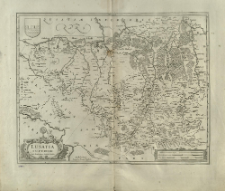
Download allTitle: Lusatia Superior
Creator:
Scultetus, Bartholomäus (1540–1614) ; Janssonius, Johannes (1588–1664) : Wyd.
Date issued/created:
Resource type:
Publisher:
Place of publishing:
Description:
Scale [ca 1:250 000] ; 1 map : copperplate engraving ; 38x48 cm ; In the upper left corner of the map, the coat of arms of Upper Lusatia ; Described sides of the world: Oriens, Meridies, Occidens, Septentrio ; IDS Basel Bern online
Detailed Resource Type:
Resource Identifier:
Source:
CBGiOŚ. IGiPZ PAN, call no. B.KS.446[35] ; click here to follow the link
Language:
Rights:
Terms of use:
Digitizing institution:
Institute of Geography and Spatial Organization of the Polish Academy of Sciences
Original in:
Projects co-financed by:
Access:
Object collections:
- Digital Repository of Scientific Institutes > Partners' collections > Institute of Geography and Spatial Organization PAS (IGiPZ PAN) > Library
- Digital Repository of Scientific Institutes > Partners' collections > Institute of Geography and Spatial Organization PAS (IGiPZ PAN) > Library > Maps and atlases
- Digital Repository of Scientific Institutes > Partners' collections > Institute of Geography and Spatial Organization PAS (IGiPZ PAN) > Library > Selected collections
- Digital Repository of Scientific Institutes > Partners' collections > Institute of Geography and Spatial Organization PAS (IGiPZ PAN) > Library > Selected collections > Prof. Józef Staszewski Collection
- Digital Repository of Scientific Institutes > Literature > Maps/Atlases
Last modified:
Mar 8, 2021
In our library since:
Feb 25, 2021
Number of object content downloads / hits:
34
All available object's versions:
https://rcin.org.pl./publication/192206
Show description in RDF format:
Show description in RDFa format:
Show description in OAI-PMH format:
| Edition name | Date |
|---|---|
| Scultetus, Bartholomäus (1540 - 1614), [ca 1680], Lusatia Superior | Mar 8, 2021 |
Objects Similar
Janssonius, Johannes (1588–1664) Pitt, Moses (1641–1697) Janssonius Van Waesberge Officina
Janssonius, Johannes (1588–1664)
Janssonius, Johannes (1588–1664) Pahl, Mikołaj (1595–1649)
Scultetus, Jonas (1603–1664) Janssonius, Johannes (1588–1664)


