- Search in all Repository
- Literature and maps
- Archeology
- Mills database
- Natural sciences
Advanced search
Advanced search
Advanced search
Advanced search
Advanced search

Object
Available formats:
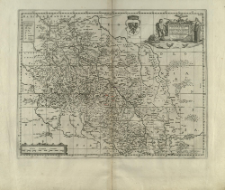
Download allTitle: Silesiæ Dvcatvs Accurata et vera delineatio
Creator:
Scultetus, Jonas (1603–1664) ; Pitt, Moses (1641–1697) : Wyd. ; Svart, Steven (1641–1683) : Wyd.
Date issued/created:
Resource type:
Subtitle:
Silesiae Ducatus Accurata et vera delineatio
Institutional creator:
Janssonius Van Waesberge Officina.
Publisher:
sumptibus Janssonio-Waesbergiorum, Mosis Pitt et Stephani Swart
Place of publishing:
Description:
Scale [ca 1:1 000 000] ; 1 map : copperplate engraving ; 38x48 cm ; After the title dedication: "Viris Magnificis AC Generosis, D. Valentino a Stöβel in Seppa Kawer. D.Sigismundo a Loβ in Simpsen Dammer. D. Caspari a Stosch. D. Davidi Gotfr. a Stosch Patruelibus in Groβ et klein Tschirna. D. Gotfried ab Haugwitz in Brodelwitz, Ziebendorf Equitibus Patronis Dicat Dedicatq[ue] Ionas Scultetus, Sprotta Silesius" ; In the upper right corner of the map, a cartouche with the title. On the left side of the cartouche on the shield the coat of arms of the Silesian eagle under the duke's miter̨. In the upper left corner, the legend: Notularum explicatio. A linear scale above the lower frame. The sides of the world are described on the map next to the frames: Septentrio, Oriens, Meridies, Occidens. On the right, under the upper frame, there is a marking: XXIV ; Place and year of publication according to: Imago Silesiae. - 2001, pp.41-42, pos. 32
Detailed Resource Type:
Resource Identifier:
Source:
CBGiOŚ. IGiPZ PAN, call no. B.KS.446[33] ; click here to follow the link
Language:
Rights:
Terms of use:
Digitizing institution:
Institute of Geography and Spatial Organization of the Polish Academy of Sciences
Original in:
Projects co-financed by:
Access:
Object collections:
- Digital Repository of Scientific Institutes > Partners' collections > Institute of Geography and Spatial Organization PAS (IGiPZ PAN) > Library
- Digital Repository of Scientific Institutes > Partners' collections > Institute of Geography and Spatial Organization PAS (IGiPZ PAN) > Library > Maps and atlases
- Digital Repository of Scientific Institutes > Partners' collections > Institute of Geography and Spatial Organization PAS (IGiPZ PAN) > Library > Selected collections
- Digital Repository of Scientific Institutes > Partners' collections > Institute of Geography and Spatial Organization PAS (IGiPZ PAN) > Library > Selected collections > Prof. Józef Staszewski Collection
- Digital Repository of Scientific Institutes > Literature > Maps/Atlases
Last modified:
Mar 8, 2021
In our library since:
Feb 25, 2021
Number of object content downloads / hits:
78
All available object's versions:
https://rcin.org.pl./publication/192092
Show description in RDF format:
Show description in RDFa format:
Show description in OAI-PMH format:
| Edition name | Date |
|---|---|
| Scultetus, Jonas (1603 - 1664), [1681], Silesiæ Dvcatvs Accurata et vera delineatio | Mar 8, 2021 |
Objects Similar
Scultetus, Jonas (1603–1664) Janssonius, Johannes (1588–1664)
Pankiewicz, Aleksandra Rodak, Sylwia
Nowakowski, Dominik
Płonka, Tomasz Diakowski, Marcin Kufel-Diakowska, Bernadeta Bronowicki, Wojciech Miazga, Beata Stefaniak, Krzysztof

 INSTYTUT ARCHEOLOGII I ETNOLOGII POLSKIEJ AKADEMII NAUK
 INSTYTUT BADAŃ LITERACKICH POLSKIEJ AKADEMII NAUK
 INSTYTUT BADAWCZY LEŚNICTWA
 INSTYTUT BIOLOGII DOŚWIADCZALNEJ IM. MARCELEGO NENCKIEGO POLSKIEJ AKADEMII NAUK
 INSTYTUT BIOLOGII SSAKÓW POLSKIEJ AKADEMII NAUK
 INSTYTUT CHEMII FIZYCZNEJ PAN
 INSTYTUT CHEMII ORGANICZNEJ PAN
 INSTYTUT FILOZOFII I SOCJOLOGII PAN
 INSTYTUT GEOGRAFII I PRZESTRZENNEGO ZAGOSPODAROWANIA PAN
 INSTYTUT HISTORII im. TADEUSZA MANTEUFFLA POLSKIEJ AKADEMII NAUK
 INSTYTUT JĘZYKA POLSKIEGO POLSKIEJ AKADEMII NAUK
 INSTYTUT MATEMATYCZNY PAN
 INSTYTUT MEDYCYNY DOŚWIADCZALNEJ I KLINICZNEJ IM.MIROSŁAWA MOSSAKOWSKIEGO POLSKIEJ AKADEMII NAUK
 INSTYTUT PODSTAWOWYCH PROBLEMÓW TECHNIKI PAN
 INSTYTUT SLAWISTYKI PAN
 SIEĆ BADAWCZA ŁUKASIEWICZ - INSTYTUT TECHNOLOGII MATERIAŁÓW ELEKTRONICZNYCH
 MUZEUM I INSTYTUT ZOOLOGII POLSKIEJ AKADEMII NAUK
 INSTYTUT BADAŃ SYSTEMOWYCH PAN
 INSTYTUT BOTANIKI IM. WŁADYSŁAWA SZAFERA POLSKIEJ AKADEMII NAUK


