- O repozytorium
- Kolekcje
- Indeksy
- Historia przeglądania
-
Repozytoria RCIN
-
 INSTYTUT ARCHEOLOGII I ETNOLOGII POLSKIEJ AKADEMII NAUK
-
 INSTYTUT BADAŃ LITERACKICH POLSKIEJ AKADEMII NAUK
-
 INSTYTUT BADAWCZY LEŚNICTWA
-
 INSTYTUT BIOLOGII DOŚWIADCZALNEJ IM. MARCELEGO NENCKIEGO POLSKIEJ AKADEMII NAUK
-
 INSTYTUT BIOLOGII SSAKÓW POLSKIEJ AKADEMII NAUK
-
 INSTYTUT CHEMII FIZYCZNEJ PAN
-
 INSTYTUT CHEMII ORGANICZNEJ PAN
-
 INSTYTUT FILOZOFII I SOCJOLOGII PAN
-
 INSTYTUT GEOGRAFII I PRZESTRZENNEGO ZAGOSPODAROWANIA PAN
-
 INSTYTUT HISTORII im. TADEUSZA MANTEUFFLA POLSKIEJ AKADEMII NAUK
-
 INSTYTUT JĘZYKA POLSKIEGO POLSKIEJ AKADEMII NAUK
-
 INSTYTUT MATEMATYCZNY PAN
-
 INSTYTUT MEDYCYNY DOŚWIADCZALNEJ I KLINICZNEJ IM.MIROSŁAWA MOSSAKOWSKIEGO POLSKIEJ AKADEMII NAUK
-
 INSTYTUT PODSTAWOWYCH PROBLEMÓW TECHNIKI PAN
-
 INSTYTUT SLAWISTYKI PAN
-
 SIEĆ BADAWCZA ŁUKASIEWICZ - INSTYTUT TECHNOLOGII MATERIAŁÓW ELEKTRONICZNYCH
-
 MUZEUM I INSTYTUT ZOOLOGII POLSKIEJ AKADEMII NAUK
-
 INSTYTUT BADAŃ SYSTEMOWYCH PAN
-
 INSTYTUT BOTANIKI IM. WŁADYSŁAWA SZAFERA POLSKIEJ AKADEMII NAUK
-

Obiekt
Dostępne formaty:
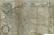
Pobierz wszystkieTytuł: Das heÿl. Römische Reich Teutscher Nation worinnen begriffen desselben Chur- und Fürstenthumber, auch länder sampt einen Theil von desselben angrentzenden Königreichen und Provinzien
Twórca:
Sanson, Nicolas (1600–1667) ; Hoffmann, Johann (1629–1698) : Wyd. ; Hipschmann, Sigmund Gabriel : Ryt. (1639-?)
Data wydania/powstania:
Typ zasobu:
Inny tytuł:
Wydawca:
Miejsce wydania:
Opis:
Scale [ca 1:2 100 000] ; 1 map : copperplate engraving ; 54x87 cm ; Title from the cartouche. Full title above the frame: L' Empire d'Allemagne, ou sont distingues Les Estats De La Mson D'Austrische, Des Eslecteurs Ecclesiastiques De Mayence, Treves, et Cologne, Des Eslecteurs Laiques, sc? Du Duc De Baviere, Du Palatin Du Rhein Du Duc De Saxe, et Du Marquis de Brandebourg, et de tous Les Estats et Souverainetés gui so dans la Souabe, Franconie, Hesse, Westphalie, Haute et Basse Saxe, ou sont encor Les Estats des Suisses, et Des Provinces Unies Des Pays Bas Les Estats de la Mson d'Austriche en Allemagne sont le Royaume et Eslectorat de Boheme l'Archiduche d'Austriche, les Duches de Stirie, Carinthie, Carniole, la Principaute' de Soüabe, le Comté de Tirol &c. a l'Empereur. la Franche Comté, et les Pays-bas Catholiques au Roy dEspagne ; The Ferro Meridian determined after the coordinates have been calculated by the cataloger ; Date of issue according to: https://opacplus.bsb-muenchen.de/metaopac/search?query=BV000267869, adjusted by years of publisher's activity (1663-1698) ; Above the lower frame in a cartouche surrounded by a garland, eight lineal scales and an explanation of the signs
Szczegółowy typ zasobu:
Identyfikator zasobu:
Źródło:
CBGiOŚ. IGiPZ PAN, call no. B.KS.446[6] ; kliknij tutaj, żeby przejść
Język:
Zakres:
Prawa:
Zasady wykorzystania:
Digitalizacja:
Institute of Geography and Spatial Organization of the Polish Academy of Sciences
Lokalizacja oryginału:
Dofinansowane ze środków:
Dostęp:
Kolekcje, do których przypisany jest obiekt:
- Repozytorium Cyfrowe Instytutów Naukowych > Kolekcje Partnerów > Instytut Geografii i Przestrzennego Zagospodarowania PAN > Biblioteka Instytutu
- Repozytorium Cyfrowe Instytutów Naukowych > Kolekcje Partnerów > Instytut Geografii i Przestrzennego Zagospodarowania PAN > Biblioteka Instytutu > Mapy i atlasy
- Repozytorium Cyfrowe Instytutów Naukowych > Kolekcje Partnerów > Instytut Geografii i Przestrzennego Zagospodarowania PAN > Biblioteka Instytutu > Wybrane księgozbiory
- Repozytorium Cyfrowe Instytutów Naukowych > Kolekcje Partnerów > Instytut Geografii i Przestrzennego Zagospodarowania PAN > Biblioteka Instytutu > Wybrane księgozbiory > Księgozbiór Prof. Józefa Staszewskiego
- Repozytorium Cyfrowe Instytutów Naukowych > Piśmiennictwo > Mapy/Atlasy
Data ostatniej modyfikacji:
8 mar 2021
Data dodania obiektu:
24 lut 2021
Liczba pobrań / odtworzeń:
40
Wszystkie dostępne wersje tego obiektu:
https://rcin.org.pl./publication/191226
Wyświetl opis w formacie RDF:
Wyświetl opis w formacie RDFa:
Wyświetl opis w formacie OAI-PMH:
Obiekty Podobne
Sanson, Nicolas (1600–1667)
Sanson, Nicolas (1600–1667)
Sanson, Nicolas (1600–1667) Somer, Jean Pruthenus (16..-16..?). Ryt.
Sanson, Nicolas (1600–1667) Mariette, Pierre (1634–1716)
Sanson, Nicolas (1600–1667) Hoffmann, Johann (1629–1698)


