- O repozytorium
- Kolekcje
- Indeksy
- Historia przeglądania
-
Repozytoria RCIN
-
 INSTYTUT ARCHEOLOGII I ETNOLOGII POLSKIEJ AKADEMII NAUK
-
 INSTYTUT BADAŃ LITERACKICH POLSKIEJ AKADEMII NAUK
-
 INSTYTUT BADAWCZY LEŚNICTWA
-
 INSTYTUT BIOLOGII DOŚWIADCZALNEJ IM. MARCELEGO NENCKIEGO POLSKIEJ AKADEMII NAUK
-
 INSTYTUT BIOLOGII SSAKÓW POLSKIEJ AKADEMII NAUK
-
 INSTYTUT CHEMII FIZYCZNEJ PAN
-
 INSTYTUT CHEMII ORGANICZNEJ PAN
-
 INSTYTUT FILOZOFII I SOCJOLOGII PAN
-
 INSTYTUT GEOGRAFII I PRZESTRZENNEGO ZAGOSPODAROWANIA PAN
-
 INSTYTUT HISTORII im. TADEUSZA MANTEUFFLA POLSKIEJ AKADEMII NAUK
-
 INSTYTUT JĘZYKA POLSKIEGO POLSKIEJ AKADEMII NAUK
-
 INSTYTUT MATEMATYCZNY PAN
-
 INSTYTUT MEDYCYNY DOŚWIADCZALNEJ I KLINICZNEJ IM.MIROSŁAWA MOSSAKOWSKIEGO POLSKIEJ AKADEMII NAUK
-
 INSTYTUT PODSTAWOWYCH PROBLEMÓW TECHNIKI PAN
-
 INSTYTUT SLAWISTYKI PAN
-
 SIEĆ BADAWCZA ŁUKASIEWICZ - INSTYTUT TECHNOLOGII MATERIAŁÓW ELEKTRONICZNYCH
-
 MUZEUM I INSTYTUT ZOOLOGII POLSKIEJ AKADEMII NAUK
-
 INSTYTUT BADAŃ SYSTEMOWYCH PAN
-
 INSTYTUT BOTANIKI IM. WŁADYSŁAWA SZAFERA POLSKIEJ AKADEMII NAUK
-
- Wyszukaj w całym Repozytorium
- Piśmiennictwo i mapy
- Archeologia
- Baza Młynów
- Nauki przyrodnicze
Wyszukiwanie zaawansowane
Wyszukiwanie zaawansowane
Wyszukiwanie zaawansowane
Wyszukiwanie zaawansowane
Wyszukiwanie zaawansowane

Obiekt
Dostępne formaty:
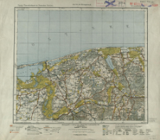
Pobierz wszystkieTytuł: Lauenburg i. Pom.
Twórca:
Prusy. Landesaufnahme. Kartographische Abteilung. Redaktor. Wydawca
Data wydania/powstania:
Typ zasobu:
Inny tytuł:
Topogr. Übersichtskarte des Deutschen Reiches ; 15. Lauenburg i. Pom. ; Topographische Übersichtskarte des Deutschen Reiches 1:200 000 ; 15. Lauenburg i. Pom.
Wydawca:
Kartogr. Abt. d. Königl. Preuß. Landesaufnahme
Miejsce wydania:
Opis:
Auflagedruck 1915 ; Scale 1:200 000 ; 1 map : color ; 30 x 34 cm, on sheet 36 x 41 cm ; Prime meridians Ferro and Greenwich
Typ obiektu:
Czasopismo/Seria/cykl:
Topographische Übersichtskarte des Deutschen Reiches 1:200 000
Szczegółowy typ zasobu:
Identyfikator zasobu:
Źródło:
CBGiOŚ. IGiPZ PAN, call no. C.770/2 ; kliknij tutaj, żeby przejść
Język:
Zakres:
Prawa:
Zasady wykorzystania:
Digitalizacja:
Institute of Geography and Spatial Organization of the Polish Academy of Sciences
Lokalizacja oryginału:
Dofinansowane ze środków:
Dostęp:
Kolekcje, do których przypisany jest obiekt:
- Repozytorium Cyfrowe Instytutów Naukowych > Kolekcje Partnerów > Instytut Geografii i Przestrzennego Zagospodarowania PAN > Biblioteka Instytutu
- Repozytorium Cyfrowe Instytutów Naukowych > Kolekcje Partnerów > Instytut Geografii i Przestrzennego Zagospodarowania PAN > Biblioteka Instytutu > Mapy i atlasy
- Repozytorium Cyfrowe Instytutów Naukowych > Piśmiennictwo > Mapy/Atlasy
Data ostatniej modyfikacji:
15 lut 2021
Data dodania obiektu:
15 lut 2021
Liczba pobrań / odtworzeń:
207
Wszystkie dostępne wersje tego obiektu:
https://rcin.org.pl./publication/181889
Wyświetl opis w formacie RDF:
Wyświetl opis w formacie RDFa:
Wyświetl opis w formacie OAI-PMH:
| Nazwa wydania | Data |
|---|---|
| 15. Lauenburg i. Pom., druk 1915 | 15 lut 2021 |
Obiekty Podobne
Prusy. Landesaufnahme. Redaktor Niemcy. Reichsamt für Landesaufnahme. Wydawca
Dokaupil, Roman (18...- 19...). Redaktor Straka, J. Redaktor Bloschitz, Rudolf Macoun, V. Redaktor


