- O repozytorium
- Kolekcje
- Indeksy
- Historia przeglądania
-
Repozytoria RCIN
-
 INSTYTUT ARCHEOLOGII I ETNOLOGII POLSKIEJ AKADEMII NAUK
-
 INSTYTUT BADAŃ LITERACKICH POLSKIEJ AKADEMII NAUK
-
 INSTYTUT BADAWCZY LEŚNICTWA
-
 INSTYTUT BIOLOGII DOŚWIADCZALNEJ IM. MARCELEGO NENCKIEGO POLSKIEJ AKADEMII NAUK
-
 INSTYTUT BIOLOGII SSAKÓW POLSKIEJ AKADEMII NAUK
-
 INSTYTUT CHEMII FIZYCZNEJ PAN
-
 INSTYTUT CHEMII ORGANICZNEJ PAN
-
 INSTYTUT FILOZOFII I SOCJOLOGII PAN
-
 INSTYTUT GEOGRAFII I PRZESTRZENNEGO ZAGOSPODAROWANIA PAN
-
 INSTYTUT HISTORII im. TADEUSZA MANTEUFFLA POLSKIEJ AKADEMII NAUK
-
 INSTYTUT JĘZYKA POLSKIEGO POLSKIEJ AKADEMII NAUK
-
 INSTYTUT MATEMATYCZNY PAN
-
 INSTYTUT MEDYCYNY DOŚWIADCZALNEJ I KLINICZNEJ IM.MIROSŁAWA MOSSAKOWSKIEGO POLSKIEJ AKADEMII NAUK
-
 INSTYTUT PODSTAWOWYCH PROBLEMÓW TECHNIKI PAN
-
 INSTYTUT SLAWISTYKI PAN
-
 SIEĆ BADAWCZA ŁUKASIEWICZ - INSTYTUT TECHNOLOGII MATERIAŁÓW ELEKTRONICZNYCH
-
 MUZEUM I INSTYTUT ZOOLOGII POLSKIEJ AKADEMII NAUK
-
 INSTYTUT BADAŃ SYSTEMOWYCH PAN
-
 INSTYTUT BOTANIKI IM. WŁADYSŁAWA SZAFERA POLSKIEJ AKADEMII NAUK
-
- Wyszukaj w całym Repozytorium
- Piśmiennictwo i mapy
- Archeologia
- Baza Młynów
- Nauki przyrodnicze
Wyszukiwanie zaawansowane
Wyszukiwanie zaawansowane
Wyszukiwanie zaawansowane
Wyszukiwanie zaawansowane
Wyszukiwanie zaawansowane

Obiekt
Dostępne formaty:
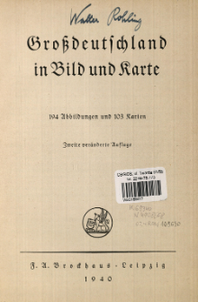
Pobierz wszystkieTytuł: Großdeutschland in Bild und Karte : 194 Abbildungen und 103 Karten
Inny tytuł:
Grossdeutschland in Bild und Karte
Wydawca:
Miejsce wydania:
Opis:
Zweite veränderte Auflage ; Scales differ ; 1 atlas (16, 136, 70 pages) : photographs, maps, color ; 26 cm ; Index of geographical names on pages 1-70
Szczegółowy typ zasobu:
Identyfikator zasobu:
Źródło:
CBGiOŚ. IGiPZ PAN, call no. B.2142 ; CBGiOŚ. IGiPZ PAN, call no. B.KS.233 ; kliknij tutaj, żeby przejść
Język:
Prawa:
Zasady wykorzystania:
Digitalizacja:
Institute of Geography and Spatial Organization of the Polish Academy of Sciences
Lokalizacja oryginału:
Dofinansowane ze środków:
Dostęp:
Kolekcje, do których przypisany jest obiekt:
- Repozytorium Cyfrowe Instytutów Naukowych > Kolekcje Partnerów > Instytut Geografii i Przestrzennego Zagospodarowania PAN > Biblioteka Instytutu > Mapy i atlasy
- Repozytorium Cyfrowe Instytutów Naukowych > Kolekcje Partnerów > Instytut Geografii i Przestrzennego Zagospodarowania PAN > Biblioteka Instytutu > Wybrane księgozbiory
- Repozytorium Cyfrowe Instytutów Naukowych > Kolekcje Partnerów > Instytut Geografii i Przestrzennego Zagospodarowania PAN > Biblioteka Instytutu > Wybrane księgozbiory > Księgozbiór Prof. Józefa Staszewskiego
- Repozytorium Cyfrowe Instytutów Naukowych > Piśmiennictwo > Mapy/Atlasy
Data ostatniej modyfikacji:
22 gru 2020
Data dodania obiektu:
22 gru 2020
Liczba pobrań / odtworzeń:
89
Wszystkie dostępne wersje tego obiektu:
https://rcin.org.pl./publication/169630
Wyświetl opis w formacie RDF:
Wyświetl opis w formacie RDFa:
Wyświetl opis w formacie OAI-PMH:
| Nazwa wydania | Data |
|---|---|
| Großdeutschland in Bild und Karte : 194 Abbildungen und 103 Karten, 1940 | 22 gru 2020 |
Obiekty Podobne
Eckert, Max (1868–1938) Sprigade, Paul (1863–1925) Moisel, Max (1869–1920) Deutsche Kolonialgesellschaft. Instytucja sprawcza Dietrich Reimer Verlag. Wydawca
Pollacchi, Paul (1862–1937) Illustration (Paryż). Wydawca
Sprigade, Paul (1863–1925) Moisel, Max (1869–1920) Deutsche Kolonialgesellschaft. Redaktor Dietrich Reimer Verlag. Wydawca
Kozenn, Blasius (1821–1871)


