- About project
- Collections
- Indexes
- Recently viewed
-
RCIN Repositories
-
 INSTYTUT ARCHEOLOGII I ETNOLOGII POLSKIEJ AKADEMII NAUK
-
 INSTYTUT BADAŃ LITERACKICH POLSKIEJ AKADEMII NAUK
-
 INSTYTUT BADAWCZY LEŚNICTWA
-
 INSTYTUT BIOLOGII DOŚWIADCZALNEJ IM. MARCELEGO NENCKIEGO POLSKIEJ AKADEMII NAUK
-
 INSTYTUT BIOLOGII SSAKÓW POLSKIEJ AKADEMII NAUK
-
 INSTYTUT CHEMII FIZYCZNEJ PAN
-
 INSTYTUT CHEMII ORGANICZNEJ PAN
-
 INSTYTUT FILOZOFII I SOCJOLOGII PAN
-
 INSTYTUT GEOGRAFII I PRZESTRZENNEGO ZAGOSPODAROWANIA PAN
-
 INSTYTUT HISTORII im. TADEUSZA MANTEUFFLA POLSKIEJ AKADEMII NAUK
-
 INSTYTUT JĘZYKA POLSKIEGO POLSKIEJ AKADEMII NAUK
-
 INSTYTUT MATEMATYCZNY PAN
-
 INSTYTUT MEDYCYNY DOŚWIADCZALNEJ I KLINICZNEJ IM.MIROSŁAWA MOSSAKOWSKIEGO POLSKIEJ AKADEMII NAUK
-
 INSTYTUT PODSTAWOWYCH PROBLEMÓW TECHNIKI PAN
-
 INSTYTUT SLAWISTYKI PAN
-
 SIEĆ BADAWCZA ŁUKASIEWICZ - INSTYTUT TECHNOLOGII MATERIAŁÓW ELEKTRONICZNYCH
-
 MUZEUM I INSTYTUT ZOOLOGII POLSKIEJ AKADEMII NAUK
-
 INSTYTUT BADAŃ SYSTEMOWYCH PAN
-
 INSTYTUT BOTANIKI IM. WŁADYSŁAWA SZAFERA POLSKIEJ AKADEMII NAUK
-

Object
Available formats:
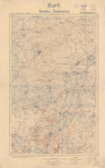
Download allTitle: Gorodno, Dombrowitza
Creator:
Prusy. Landesaufnahme. Kartographische Abteilung. Wydawca
Date issued/created:
Resource type:
Subtitle:
Karte des westlichen Russlands. Kriegsausgabe ; Blatt 6 ; Karte des westlichen Rußlands 1:100 000 ; Blatt 6. Gorodno, Dombrowitza
Publisher:
Kartogr. Abteilung der Kgl. Preuß Landesausnahme
Place of publishing:
Description:
Skala 1:100 000 ; 1 mapa : kolorowa ; 57 x 37 cm, na arkuszu 68 x 45 cm ; Arkusz zbiorczy zawiera 2 arkusze mapy seryjnej Karte des westliche Russlands 1:100 000: T 34 Gorodno i T 35 Dombrowitza ; Adnotacje na marginesie: B.11.17 ; Nur für Dienstgebrauch ! ; Południk zerowy Ferro
Relation:
Karte des westlichen Rußlands 1:100 000
Detailed Resource Type:
Resource Identifier:
Source:
CBGiOŚ. IGiPZ PAN, sygn. C.135/5 ; click here to follow the link
Language:
Coverage:
Rights:
Terms of use:
Digitizing institution:
Instytut Geografii i Przestrzennego Zagospodarowania Polskiej Akademii Nauk
Original in:
Projects co-financed by:
Access:
Object collections:
- Digital Repository of Scientific Institutes > Partners' collections > Institute of Geography and Spatial Organization PAS (IGiPZ PAN) > Library
- Digital Repository of Scientific Institutes > Partners' collections > Institute of Geography and Spatial Organization PAS (IGiPZ PAN) > Library > Maps and atlases
- Digital Repository of Scientific Institutes > Partners' collections > Institute of Geography and Spatial Organization PAS (IGiPZ PAN) > Library > Selected collections > Polish Geographical Society Collection
- Digital Repository of Scientific Institutes > Literature > Maps/Atlases
Last modified:
Dec 22, 2020
In our library since:
Dec 22, 2020
Number of object content downloads / hits:
41
All available object's versions:
https://rcin.org.pl./publication/160173
Show description in RDF format:
Show description in RDFa format:
Show description in OAI-PMH format:
| Edition name | Date |
|---|---|
| Gorodno, Dombrowitza, druk 1917 | Dec 22, 2020 |
Objects Similar
Prusy. Landesaufnahme. Kartographische Abteilung. Wydawca
Prusy. Landesaufnahme. Kartographische Abteilung. Wydawca
Prusy. Landesaufnahme. Kartographische Abteilung. Instytucja sprawcza Wydawca
Prusy. Landesaufnahme. Kartographische Abteilung. Instytucja sprawcza Wydawca
Prusy. Landesaufnahme. Kartographische Abteilung. Instytucja sprawcza Wydawca
Prusy. Landesaufnahme. Kartographische Abteilung. Redaktor. Wydawca


