- Search in all Repository
- Literature and maps
- Archeology
- Mills database
- Natural sciences
Advanced search
Advanced search
Advanced search
Advanced search
Advanced search

Object
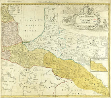
Title: Le Duche de Semgalle ; Perillustribus, Generosissimis Magnificis & Excellentissimis Dominis, Dominis Ducatuum Curlandiae & Semgalliae quatuor Consiliariis supremis tabulam hanc Ducatuum Curlandiae & Semgalliae geographicam
Publisher:
Place of publishing:
Description:
Scale [ca 1:420 000], bar scale: Milliaria Geographica 15 unius Gradus ; 1 map in 2 segment on 1 sheet : copperplate engraving, hand col. ; 49x57 cm,on sheet 56x65 cm ; Map was published independent and published in: Nouvel atlas de la société cosmographique. - [Nuremberg], Heristiers de Homann, 1747. Map was conected with: Ducatus Curlandiae[...] / Barnikel Johann Christoph. - Norimbergae, 1747 ; Single neat line on the left - the map can be connected with: Ducatus Curlandiae[...] / Barnikel Johann Christoph. - Norimbergae, 1747 ; Prime meridian Ferro ; Cited in: Katalog zbiorów kartograficznych Muzeum Zamkowego w Malborku / Artur Dobry. - Malbork, 2005 poz. 35, p. 47 ; Cited in: Centralny katalog zbiorów kartograficznych w Polsce, Z. 5, poz. 7, p. 7
Detailed Resource Type:
Format:
File size 2,5 MB ; image/x.djvu
Resource Identifier:
Source:
CBGiOŚ. IGiPZ PAN, sygn. Ds.8286/2 [I.6C-3b] ; CBGiOŚ. IGiPZ PAN, sygn. Ds.8944/2 [I.6C-2] ; click here to follow the link
Language:
Rights:
Terms of use:
Digitizing institution:
Institute of Geography and Spatial Organization of the Polish Academy of Sciences
Original in:
Projects co-financed by:
Programme Innovative Economy, 2010-2014, Priority Axis 2. R&D infrastructure ; European Union. European Regional Development Fund
Access:
Object collections:
- Digital Repository of Scientific Institutes > Partners' collections > Institute of Geography and Spatial Organization PAS (IGiPZ PAN) > Library
- Digital Repository of Scientific Institutes > Partners' collections > Institute of Geography and Spatial Organization PAS (IGiPZ PAN) > Library > Maps and atlases
- Digital Repository of Scientific Institutes > Literature > Maps/Atlases
Last modified:
Oct 2, 2020
In our library since:
Jul 4, 2012
Number of object content downloads / hits:
125
All available object's versions:
https://rcin.org.pl./publication/15815
Show description in RDF format:
Show description in RDFa format:
Show description in OAI-PMH format:
Objects Similar
Homännische Erben
Homännische Erben
Hase, Johann Matthias (1684–1742) Schneider, Ruprecht A Homännische - Erben

 INSTYTUT ARCHEOLOGII I ETNOLOGII POLSKIEJ AKADEMII NAUK
 INSTYTUT BADAŃ LITERACKICH POLSKIEJ AKADEMII NAUK
 INSTYTUT BADAWCZY LEŚNICTWA
 INSTYTUT BIOLOGII DOŚWIADCZALNEJ IM. MARCELEGO NENCKIEGO POLSKIEJ AKADEMII NAUK
 INSTYTUT BIOLOGII SSAKÓW POLSKIEJ AKADEMII NAUK
 INSTYTUT CHEMII FIZYCZNEJ PAN
 INSTYTUT CHEMII ORGANICZNEJ PAN
 INSTYTUT FILOZOFII I SOCJOLOGII PAN
 INSTYTUT GEOGRAFII I PRZESTRZENNEGO ZAGOSPODAROWANIA PAN
 INSTYTUT HISTORII im. TADEUSZA MANTEUFFLA POLSKIEJ AKADEMII NAUK
 INSTYTUT JĘZYKA POLSKIEGO POLSKIEJ AKADEMII NAUK
 INSTYTUT MATEMATYCZNY PAN
 INSTYTUT MEDYCYNY DOŚWIADCZALNEJ I KLINICZNEJ IM.MIROSŁAWA MOSSAKOWSKIEGO POLSKIEJ AKADEMII NAUK
 INSTYTUT PODSTAWOWYCH PROBLEMÓW TECHNIKI PAN
 INSTYTUT SLAWISTYKI PAN
 SIEĆ BADAWCZA ŁUKASIEWICZ - INSTYTUT TECHNOLOGII MATERIAŁÓW ELEKTRONICZNYCH
 MUZEUM I INSTYTUT ZOOLOGII POLSKIEJ AKADEMII NAUK
 INSTYTUT BADAŃ SYSTEMOWYCH PAN
 INSTYTUT BOTANIKI IM. WŁADYSŁAWA SZAFERA POLSKIEJ AKADEMII NAUK


