- About project
- Collections
- Indexes
- Recently viewed
-
RCIN Repositories
-
 INSTYTUT ARCHEOLOGII I ETNOLOGII POLSKIEJ AKADEMII NAUK
-
 INSTYTUT BADAŃ LITERACKICH POLSKIEJ AKADEMII NAUK
-
 INSTYTUT BADAWCZY LEŚNICTWA
-
 INSTYTUT BIOLOGII DOŚWIADCZALNEJ IM. MARCELEGO NENCKIEGO POLSKIEJ AKADEMII NAUK
-
 INSTYTUT BIOLOGII SSAKÓW POLSKIEJ AKADEMII NAUK
-
 INSTYTUT CHEMII FIZYCZNEJ PAN
-
 INSTYTUT CHEMII ORGANICZNEJ PAN
-
 INSTYTUT FILOZOFII I SOCJOLOGII PAN
-
 INSTYTUT GEOGRAFII I PRZESTRZENNEGO ZAGOSPODAROWANIA PAN
-
 INSTYTUT HISTORII im. TADEUSZA MANTEUFFLA POLSKIEJ AKADEMII NAUK
-
 INSTYTUT JĘZYKA POLSKIEGO POLSKIEJ AKADEMII NAUK
-
 INSTYTUT MATEMATYCZNY PAN
-
 INSTYTUT MEDYCYNY DOŚWIADCZALNEJ I KLINICZNEJ IM.MIROSŁAWA MOSSAKOWSKIEGO POLSKIEJ AKADEMII NAUK
-
 INSTYTUT PODSTAWOWYCH PROBLEMÓW TECHNIKI PAN
-
 INSTYTUT SLAWISTYKI PAN
-
 SIEĆ BADAWCZA ŁUKASIEWICZ - INSTYTUT TECHNOLOGII MATERIAŁÓW ELEKTRONICZNYCH
-
 MUZEUM I INSTYTUT ZOOLOGII POLSKIEJ AKADEMII NAUK
-
 INSTYTUT BADAŃ SYSTEMOWYCH PAN
-
 INSTYTUT BOTANIKI IM. WŁADYSŁAWA SZAFERA POLSKIEJ AKADEMII NAUK
-
- Search in all Repository
- Literature and maps
- Archeology
- Mills database
- Natural sciences
Advanced search
Advanced search
Advanced search
Advanced search
Advanced search

Object
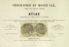
Title: Géographie du moyen age : atlas composé de cinquante planches
Publisher:
Chez Vve et J. Pilliet, Libraires, Successeurs de P.- J. Voglet
Place of publishing:
Description:
Skales differ ; 1 atlas (XIV, [3] p., [49] l., 30 p.) : copperplate engraving, maps some col. ; 23x35 cm ; Cited in: Estr. XIX, t. 2. s. 565
Detailed Resource Type:
Format:
File size 31,3 MB ; image/x.djvu
Resource Identifier:
Source:
CBGiOŚ. IGiPZ PAN, sygn. B.491 ; CBGiOŚ. IGiPZ PAN, sygn. B.KS.242 ; click here to follow the link
Language:
Rights:
Terms of use:
Digitizing institution:
Institute of Geography and Spatial Organization of the Polish Academy of Sciences
Original in:
Projects co-financed by:
Programme Innovative Economy, 2010-2014, Priority Axis 2. R&D infrastructure ; European Union. European Regional Development Fund
Access:
Object collections:
- Digital Repository of Scientific Institutes > Partners' collections > Institute of Geography and Spatial Organization PAS (IGiPZ PAN) > Library
- Digital Repository of Scientific Institutes > Partners' collections > Institute of Geography and Spatial Organization PAS (IGiPZ PAN) > Library > Maps and atlases
- Digital Repository of Scientific Institutes > Partners' collections > Institute of Geography and Spatial Organization PAS (IGiPZ PAN) > Library > Selected collections > Prof. Józef Staszewski Collection
- Digital Repository of Scientific Institutes > Literature > Maps/Atlases
Last modified:
Oct 2, 2020
In our library since:
Apr 13, 2012
Number of object content downloads / hits:
1024
All available object's versions:
https://rcin.org.pl./publication/12524
Show description in RDF format:
Show description in RDFa format:
Show description in OAI-PMH format:
| Edition name | Date |
|---|---|
| Lelewel, Joachim (1786-1861), 1850, Géographie du moyen age : atlas composé de cinquante planches | Oct 2, 2020 |
Objects Similar
Nałęcz-Korzeniowska, Maria Regina (1793–1874) Lelewel, Joachim (1786–1861) Gałęzowski, Antoni ( –1830) Dayczer, Karol Szymon
Lelewel, Joachim (1786–1861)
Drioux, Claude Joseph (1820–1898) Leroy, Charles
Nylén, Erik (1918– )


