- Search in all Repository
- Literature and maps
- Archeology
- Mills database
- Natural sciences
Advanced search
Advanced search
Advanced search
Advanced search
Advanced search

Object
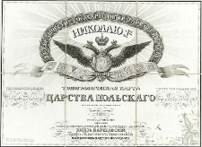
Title: Topografičeskaâ karta Carstva Pol'skago = Topograficzna karta Królestwa Polskiego = Carte topographique du Royaume de Pologne
Subtitle:
Mapa Kwatermistrzostwa ; Topograficzna karta Królestwa Polskiego ; Carte topographique du Royaume de Pologne
Publisher:
[Oddział Korpusu Topografów (armii rosyjskiej) do Pomiarów Królestwa Polskiego] ; [Kwatermistrzostwo Generalne Wojska Polskiego]
Place of publishing:
Description:
Scale 1:126 000i ; Maps : copperplate engraving, col. ; on sheets 41x55 cm or 20x55 cm + index map on sheet 59x47 cm ; Title from title sheet ; Date on title sheet: 1839 ; Complete in 60 sheets and 1 sheet index ; Designation of edition, date, place and name of publisher from: Centralnym Katalogiem Zbiorów Kartograficznych w Polsce.Variant title from: Topograficzna Karta Królestwa Polskiego (1822-1843) / Bogusław Krassowski. - Warszawa, 1978 ; Prime meridian Warsaw ; Cited in: Centralny Katalog Zbiorów Kartograficznych w Polsce, z. 5, cz. 1, poz. 104
Detailed Resource Type:
Format:
File size 215 MB ; image/x.djvu
Resource Identifier:
Source:
CBGiOŚ. IGiPZ PAN, sygn. C.542 [IX -6a] ; click here to follow the link
Language:
Rights:
Terms of use:
Digitizing institution:
Institute of Geography and Spatial Organization of the Polish Academy of Sciences
Original in:
Projects co-financed by:
Programme Innovative Economy, 2010-2014, Priority Axis 2. R&D infrastructure ; European Union. European Regional Development Fund
Access:
Object collections:
- Digital Repository of Scientific Institutes > Partners' collections > Institute of Geography and Spatial Organization PAS (IGiPZ PAN) > Library
- Digital Repository of Scientific Institutes > Partners' collections > Institute of Geography and Spatial Organization PAS (IGiPZ PAN) > Library > Maps and atlases
- Digital Repository of Scientific Institutes > Literature > Maps/Atlases
Last modified:
Oct 2, 2020
In our library since:
Nov 22, 2011
Number of object content downloads / hits:
19902
All available object's versions:
https://rcin.org.pl./publication/12322
Show description in RDF format:
Show description in RDFa format:
Show description in OAI-PMH format:
Objects Similar
Woźny, Marzena
Skimborowicz, Hipolit Red. Zakrzewski, Walenty Red. Jenike, Ludwik Red.
Skimborowicz, Hipolit Red. Zakrzewski, Walenty Red. Jenike, Ludwik Red.
Skimborowicz, Hipolit Red. Zakrzewski, Walenty Red. Jenike, Ludwik Red.
Skimborowicz, Hipolit Red. Zakrzewski, Walenty Red. Jenike, Ludwik Red.
Skimborowicz, Hipolit Red. Zakrzewski, Walenty Red. Jenike, Ludwik Red.
Skimborowicz, Hipolit Red. Zakrzewski, Walenty Red. Jenike, Ludwik Red.
Skimborowicz, Hipolit Red. Zakrzewski, Walenty Red. Jenike, Ludwik Red.

 INSTYTUT ARCHEOLOGII I ETNOLOGII POLSKIEJ AKADEMII NAUK
 INSTYTUT BADAŃ LITERACKICH POLSKIEJ AKADEMII NAUK
 INSTYTUT BADAWCZY LEŚNICTWA
 INSTYTUT BIOLOGII DOŚWIADCZALNEJ IM. MARCELEGO NENCKIEGO POLSKIEJ AKADEMII NAUK
 INSTYTUT BIOLOGII SSAKÓW POLSKIEJ AKADEMII NAUK
 INSTYTUT CHEMII FIZYCZNEJ PAN
 INSTYTUT CHEMII ORGANICZNEJ PAN
 INSTYTUT FILOZOFII I SOCJOLOGII PAN
 INSTYTUT GEOGRAFII I PRZESTRZENNEGO ZAGOSPODAROWANIA PAN
 INSTYTUT HISTORII im. TADEUSZA MANTEUFFLA POLSKIEJ AKADEMII NAUK
 INSTYTUT JĘZYKA POLSKIEGO POLSKIEJ AKADEMII NAUK
 INSTYTUT MATEMATYCZNY PAN
 INSTYTUT MEDYCYNY DOŚWIADCZALNEJ I KLINICZNEJ IM.MIROSŁAWA MOSSAKOWSKIEGO POLSKIEJ AKADEMII NAUK
 INSTYTUT PODSTAWOWYCH PROBLEMÓW TECHNIKI PAN
 INSTYTUT SLAWISTYKI PAN
 SIEĆ BADAWCZA ŁUKASIEWICZ - INSTYTUT TECHNOLOGII MATERIAŁÓW ELEKTRONICZNYCH
 MUZEUM I INSTYTUT ZOOLOGII POLSKIEJ AKADEMII NAUK
 INSTYTUT BADAŃ SYSTEMOWYCH PAN
 INSTYTUT BOTANIKI IM. WŁADYSŁAWA SZAFERA POLSKIEJ AKADEMII NAUK


