- O repozytorium
- Kolekcje
- Indeksy
- Historia przeglądania
-
Repozytoria RCIN
-
 INSTYTUT ARCHEOLOGII I ETNOLOGII POLSKIEJ AKADEMII NAUK
-
 INSTYTUT BADAŃ LITERACKICH POLSKIEJ AKADEMII NAUK
-
 INSTYTUT BADAWCZY LEŚNICTWA
-
 INSTYTUT BIOLOGII DOŚWIADCZALNEJ IM. MARCELEGO NENCKIEGO POLSKIEJ AKADEMII NAUK
-
 INSTYTUT BIOLOGII SSAKÓW POLSKIEJ AKADEMII NAUK
-
 INSTYTUT CHEMII FIZYCZNEJ PAN
-
 INSTYTUT CHEMII ORGANICZNEJ PAN
-
 INSTYTUT FILOZOFII I SOCJOLOGII PAN
-
 INSTYTUT GEOGRAFII I PRZESTRZENNEGO ZAGOSPODAROWANIA PAN
-
 INSTYTUT HISTORII im. TADEUSZA MANTEUFFLA POLSKIEJ AKADEMII NAUK
-
 INSTYTUT JĘZYKA POLSKIEGO POLSKIEJ AKADEMII NAUK
-
 INSTYTUT MATEMATYCZNY PAN
-
 INSTYTUT MEDYCYNY DOŚWIADCZALNEJ I KLINICZNEJ IM.MIROSŁAWA MOSSAKOWSKIEGO POLSKIEJ AKADEMII NAUK
-
 INSTYTUT PODSTAWOWYCH PROBLEMÓW TECHNIKI PAN
-
 INSTYTUT SLAWISTYKI PAN
-
 SIEĆ BADAWCZA ŁUKASIEWICZ - INSTYTUT TECHNOLOGII MATERIAŁÓW ELEKTRONICZNYCH
-
 MUZEUM I INSTYTUT ZOOLOGII POLSKIEJ AKADEMII NAUK
-
 INSTYTUT BADAŃ SYSTEMOWYCH PAN
-
 INSTYTUT BOTANIKI IM. WŁADYSŁAWA SZAFERA POLSKIEJ AKADEMII NAUK
-
- Wyszukaj w całym Repozytorium
- Piśmiennictwo i mapy
- Archeologia
- Baza Młynów
- Nauki przyrodnicze
Wyszukiwanie zaawansowane
Wyszukiwanie zaawansowane
Wyszukiwanie zaawansowane
Wyszukiwanie zaawansowane
Wyszukiwanie zaawansowane

Obiekt
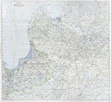
Tytuł: Übersichtskarte von Ostpreussen, Kurland und den angrenzenden Gebieten : 1:750 000 ; Übersichtskarte von Ostpreussen, Kurland und den anschliessenden Gebieten ; Lechners Kriegskarten ; 12
Twórca:
Kaiserlich-Königliches Militär-Geographisches Institut (Wiedeń)
Data wydania/powstania:
Typ zasobu:
Wydawca:
Verlag der k. u. k. Hof- und Universitatsbuchhandlung R. Lechner (W. Müller)
Miejsce wydania:
Opis:
Scale 1:750 000 ; 1 map : col. ; 80x88 cm, folded to 20x14 cm ; Prime meridian Ferro ; Without legend of signs and symbols
Czasopismo/Seria/cykl:
Szczegółowy typ zasobu:
Format:
File size 7,5 MB ; image/x.djvu
Identyfikator zasobu:
Źródło:
CBGiOŚ. IGiPZ PAN, sygn.D.6597 [II.5A-10] ; kliknij tutaj, żeby przejść
Język:
Prawa:
Zasady wykorzystania:
Digitalizacja:
Institute of Geography and Spatial Organization of the Polish Academy of Sciences
Lokalizacja oryginału:
Dofinansowane ze środków:
Programme Innovative Economy, 2010-2014, Priority Axis 2. R&D infrastructure ; European Union. European Regional Development Fund
Dostęp:
Kolekcje, do których przypisany jest obiekt:
- Repozytorium Cyfrowe Instytutów Naukowych > Kolekcje Partnerów > Instytut Geografii i Przestrzennego Zagospodarowania PAN > Biblioteka Instytutu
- Repozytorium Cyfrowe Instytutów Naukowych > Kolekcje Partnerów > Instytut Geografii i Przestrzennego Zagospodarowania PAN > Biblioteka Instytutu > Mapy i atlasy
- Repozytorium Cyfrowe Instytutów Naukowych > Piśmiennictwo > Mapy/Atlasy
Data ostatniej modyfikacji:
2 paź 2020
Data dodania obiektu:
2 sie 2012
Liczba pobrań / odtworzeń:
339
Wszystkie dostępne wersje tego obiektu:
https://rcin.org.pl./publication/12166
Wyświetl opis w formacie RDF:
Wyświetl opis w formacie RDFa:
Wyświetl opis w formacie OAI-PMH:
| Nazwa wydania | Data |
|---|---|
| Übersichtskarte von Ostpreussen, Kurland und den angrenzenden Gebieten : 1:750 000, [ca 1915] | 2 paź 2020 |
Obiekty Podobne
Kaiserlich-Königliches Militär-Geographisches Institut (Wiedeń)
Kaiserlich-Königliches Militär-Geographisches Institut (Wiedeń)
Mährisch-schlesischer Sudeten-Gebirgsverein Kaiserlich-Königliches Militär-Geographisches Institut (Wiedeń)
Tomaszewski, Adam (1895–1945) Kaiserlich-Königliches Militär-Geographisches Institut (Wiedeń)
Kaiserlich-Königliches Militär-Geographisches Institut (Wiedeń)
Kaiserlich-Königliches Militär-Geographisches Institut (Wiedeń)


